IMAGES TAKEN NEAR TO
Nimrod Way, East Dorset Trade Park, WIMBORNE, BH21 7SH
Introduction
This page details the photographs taken nearby to Nimrod Way, East Dorset Trade Park, BH21 7SH by members of the Geograph project.
The Geograph project started in 2005 with the aim of publishing, organising and preserving representative images for every square kilometre of Great Britain, Ireland and the Isle of Man.

There are currently over 7.5m images from over14,400 individuals and you can help contribute to the project by visiting https://www.geograph.org.uk
Image Map (Loading...)


Getting Data...Please wait
Leaflet Map data © OpenStreetMap
Images are licensed for reuse under creativecommons.org/licenses/by-sa/2.0
Notes
- Clicking on the map will re-center to the selected point.
- The higher the marker number, the further away the image location is from the centre of the postcode.
Image Listing (6 Images Found)
Images are licensed for reuse under creativecommons.org/licenses/by-sa/2.0
Image
Details
Distance
1

Line of Castleman Railway, Ferndown
Looking south west along the track bed of the former Castleman Railway, which closed in 1964.
The Castleman Trialway is about 300 metres to the north west and has not followed the line of the old railway since the centre of West Moors. However, it rejoins the old railway at Merley and follows the line to just north of Upton Park.
Image: © Lorraine and Keith Bowdler
Taken: 11 Mar 2010
0.07 miles
2
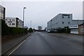
Cobham Road, Ferndown Industrial Estate
A grey road, on a grey day.
Image: © David Lally
Taken: 4 Feb 2017
0.17 miles
3

Stapehill, mast
Telecom mast at the north-eastern corner of Uddens Trading Estate.
Image: © Mike Faherty
Taken: 28 Nov 2009
0.19 miles
4

Industrial Estate Ferndown
This large delivery articulated lorry was reversing along one of the many service roads just off Old Forge Road which provide access to a range of small business and industrial units.
Image: © Nigel Mykura
Taken: 28 Mar 2013
0.21 miles
5

Stapehill: postbox №s BH21 186 and 522, Cobham Road
The ordinary box, on the left, is for stamped mail and is emptied at 5:45pm on weekdays and at 9am on Saturdays. The modern one on the right is for franked mail and is emptied finally at 6:30pm on weekdays only.
Although the industrial estate is named after Ferndown, it is in BH21 (Wimborne) rather than BH22 (Ferndown) postally. Ferndown came under Wimborne until 1990, two decades after the estate was built, so the anomaly was created then.
Image: © Chris Downer
Taken: 15 Jun 2009
0.23 miles
6
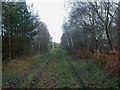
Stapehill, forest track
North of Blunt's Farm, the made-up road becomes a track, roughly parallel to A31, and servicing the southern, detached part of Uddens Plantation.
Image: © Mike Faherty
Taken: 28 Nov 2009
0.24 miles