IMAGES TAKEN NEAR TO
Stour Close, WIMBORNE, BH21 7LU
Introduction
This page details the photographs taken nearby to Stour Close, BH21 7LU by members of the Geograph project.
The Geograph project started in 2005 with the aim of publishing, organising and preserving representative images for every square kilometre of Great Britain, Ireland and the Isle of Man.

There are currently over 7.5m images from over14,400 individuals and you can help contribute to the project by visiting https://www.geograph.org.uk
Image Map (Loading...)


Getting Data...Please wait
Leaflet Map data © OpenStreetMap
Images are licensed for reuse under creativecommons.org/licenses/by-sa/2.0
Notes
- Clicking on the map will re-center to the selected point.
- The higher the marker number, the further away the image location is from the centre of the postcode.
Image Listing (10 Images Found)
Images are licensed for reuse under creativecommons.org/licenses/by-sa/2.0
Image
Details
Distance
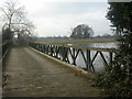
3
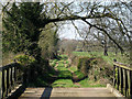
Across the bridge at Little Canford
Looking across the private bridge at Little Canford along the grass track leading to Canford School.
Image: © Peter Kazmierczak
Taken: 28 Mar 2012
0.13 miles
4
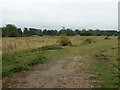
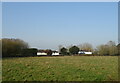
Castleman Trailway near Little Canford
View of meadows and grazing land next to the River Stour
Image: © John Smitten
Taken: 26 Jul 2005
0.13 miles
5
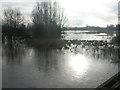
Little Canford, bridge
Private bridge over the River Stour to Canford School. The Stour is very swollen after several days of almost continuous rain, and has burst its banks, flooding local fields and the golf club.
Image: © Mike Faherty
Taken: 1 May 2012
0.13 miles
6
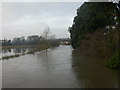
Little Canford, River Stour
Looking upstream, Manor Farm visible in the middle distance; as seen from girder bridge Image
Image: © Mike Faherty
Taken: 15 Dec 2008
0.13 miles
7
Canford Magna, floodplain
The River Stour regularly breaks its banks in winter; everything beyond the clump of trees in the middle ground is fields when dry. As seen from the girder bridge Image
Image: © Mike Faherty
Taken: 15 Dec 2008
0.13 miles
8
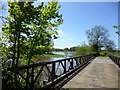
Little Canford, Bailey Bridge
Private bridge over the River Stour, from Little Canford to Canford Magna; girder and planks.
In the Experimental Bridge Establishment in Christchurch, bridges of various types were designed for the army. When the modified First World War bridge failed to carry new tanks, the ideas of Donald Bailey (later Sir) were accepted. The bridge photographed at Little Canford is a copy of the 4500 Bailey Bridges used in the Second World War in Europe. There were more used in Asia.
There is another Bailey Bridge, albeit a lot shorter, on Stanpit Marsh http://www.geograph.org.uk/photo/1051074 .
Image: © Mike Faherty
Taken: 15 Dec 2008
0.13 miles
9
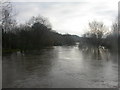
Little Canford, River Stour
Very swollen river after prolonged wet weather, looking downstream towards Knighton. As seen from girder bridge Image
Image: © Mike Faherty
Taken: 15 Dec 2008
0.13 miles