IMAGES TAKEN NEAR TO
Deans Grove, WIMBORNE, BH21 7AE
Introduction
This page details the photographs taken nearby to Deans Grove, BH21 7AE by members of the Geograph project.
The Geograph project started in 2005 with the aim of publishing, organising and preserving representative images for every square kilometre of Great Britain, Ireland and the Isle of Man.

There are currently over 7.5m images from over14,400 individuals and you can help contribute to the project by visiting https://www.geograph.org.uk
Image Map
Images are licensed for reuse under creativecommons.org/licenses/by-sa/2.0
Notes
- Clicking on the map will re-center to the selected point.
- The higher the marker number, the further away the image location is from the centre of the postcode.
Image Listing (28 Images Found)
Images are licensed for reuse under creativecommons.org/licenses/by-sa/2.0
Image
Details
Distance
1
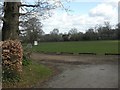
Deans Grove, playing fields
Playing fields belonging to Image, on the other side of Deans Grove.
Image: © Mike Faherty
Taken: 4 Apr 2010
0.04 miles
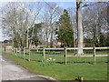
2

Main House Dumpton School
A photograph by the school caretaker of the main house at Dumpton School, Deans Grove.
Image: © Sid Alberges
Taken: 11 Nov 2008
0.06 miles
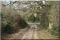
3
Deans Grove, lane junction
To the left, Deans Grove; to the right, a nameless lane to Burt's Hill further to the North-east.
Image: © Mike Faherty
Taken: 4 Apr 2010
0.07 miles
4
Deans Grove, Dumpton School
Private co-educational school on Deans Grove. http://www.dumpton.com/about_us.html
Image: © Mike Faherty
Taken: 4 Apr 2010
0.08 miles
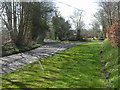
5
NEW
Footpath on track approaching Long Lane
Image: © David Martin
Taken: 11 Mar 2025
0.10 miles
6
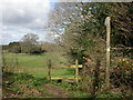
Deans Grove, stile
At the southern end of the footpath from Deans Grove to Dogdean.
Image: © Mike Faherty
Taken: 4 Apr 2010
0.11 miles
7
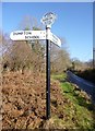
Old Direction Sign - Signpost by Deans Grove, Colehill Parish
Annulus and bar finial - 2 arms; Dorset halo with NGR by the UC road, in parish of Colehill (East Dorset District), Long Lane junction with Deans Grove, road to Dumpton School, on verge.
Surveyed
Milestone Society National ID: DO_SU0101
Image: © Milestone Society
Taken: Unknown
0.11 miles
8

Colehill: detail of the Horns Inn signpost
A closer look at the roundel on top of the Image, showing the name Horns Inn and the six-figure grid reference.
Image: © Chris Downer
Taken: 8 Feb 2015
0.12 miles
9

Colehill: signpost on Burts Hill
The signpost has on top of it a traditional Dorset roundel, giving location name and six-figure grid reference. See Image for a close-up of the roundel.
Image: © Chris Downer
Taken: 8 Feb 2015
0.12 miles
10
Deans Grove, spring
On the footpath from Deans Grove to Dogdean; houses in Dogdean in the distance.
Image: © Mike Faherty
Taken: 4 Apr 2010
0.13 miles