IMAGES TAKEN NEAR TO
Albany Drive, WIMBORNE, BH21 6YY
Introduction
This page details the photographs taken nearby to Albany Drive, BH21 6YY by members of the Geograph project.
The Geograph project started in 2005 with the aim of publishing, organising and preserving representative images for every square kilometre of Great Britain, Ireland and the Isle of Man.

There are currently over 7.5m images from over14,400 individuals and you can help contribute to the project by visiting https://www.geograph.org.uk
Image Map
Images are licensed for reuse under creativecommons.org/licenses/by-sa/2.0
Notes
- Clicking on the map will re-center to the selected point.
- The higher the marker number, the further away the image location is from the centre of the postcode.
Image Listing (30 Images Found)
Images are licensed for reuse under creativecommons.org/licenses/by-sa/2.0
Image
Details
Distance
1
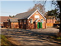
Three Legged Cross First School
Single storey school on Church Road. http://www.threeleggedcross.dorset.sch.uk/
Image: © Mike Faherty
Taken: 28 Dec 2009
0.08 miles
2
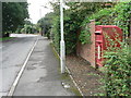
Three Legged Cross: postbox № BH21 207, Church Road
This postbox is opposite the entrance to Image
Image: © Chris Downer
Taken: 7 Sep 2008
0.08 miles
3
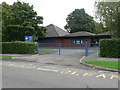
Three Legged Cross: first school
Three Legged Cross First School is a relatively modern school building in Church Road.
Image: © Chris Downer
Taken: 7 Sep 2008
0.09 miles
4
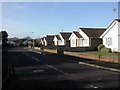
Three Legged Cross, West Avenue
Modern bungalows in a cul-de-sac off Church Road.
Image: © Mike Faherty
Taken: 28 Dec 2009
0.11 miles
6
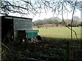
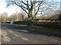
Three Legged Cross, paddock
Open land South of Verwood comprises the occasional farm, nurseries and paddocks. This is between Village Hall Lane and Church Road.
Image: © Mike Faherty
Taken: 28 Dec 2009
0.11 miles
7
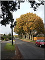
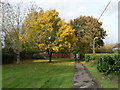
Three Legged Cross: an autumny feel in Church Road
A line of large trees on the eastern side of Church Road gives a splash of colour as it catches the sun; we haven't had much sun so far this November!
Image: © Chris Downer
Taken: 8 Nov 2008
0.12 miles
8
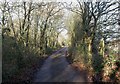
Three Legged Cross, trackbed
Trackbed of the old Salisbury and Dorset Junction Railway, from Salisbury to West Moors and Wimborne; opened 1866, closed 1964. Currently a bridleway from Three Legged Cross to Horton Common. http://en.wikipedia.org/wiki/Salisbury_and_Dorset_Junction_Railway
Image: © Mike Faherty
Taken: 28 Dec 2009
0.14 miles
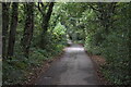
9
Three Legged Cross: village hall
Situated up a little lane off Ringwood Road.
Image: © Chris Downer
Taken: 7 Mar 2010
0.15 miles
10
Three Legged Cross: small lawn by Church Road
The pavement of Church Road is separated from the latter by a small hedge for a short distance here, as it runs alongside this pleasant lawn. The central tree shows off its autumn colour.
Image: © Chris Downer
Taken: 8 Nov 2008
0.16 miles