IMAGES TAKEN NEAR TO
Verwood Road, WIMBORNE, BH21 6RP
Introduction
This page details the photographs taken nearby to Verwood Road, BH21 6RP by members of the Geograph project.
The Geograph project started in 2005 with the aim of publishing, organising and preserving representative images for every square kilometre of Great Britain, Ireland and the Isle of Man.

There are currently over 7.5m images from over14,400 individuals and you can help contribute to the project by visiting https://www.geograph.org.uk
Image Map (Loading...)


Getting Data...Please wait
Leaflet Map data © OpenStreetMap
Images are licensed for reuse under creativecommons.org/licenses/by-sa/2.0
Notes
- Clicking on the map will re-center to the selected point.
- The higher the marker number, the further away the image location is from the centre of the postcode.
Image Listing (4 Images Found)
Images are licensed for reuse under creativecommons.org/licenses/by-sa/2.0
Image
Details
Distance
1
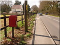
Three Legged Cross: postbox № BH21 97, Verwood Road
This little postbox, the northernmost of the three boxes in the village, is emptied finally at 11am on weekdays and at 9:30am on Saturdays. It backs onto the grounds of Chota Farm.
Image: © Chris Downer
Taken: 29 Mar 2009
0.03 miles
2
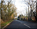
Crab Orchard
Approaching Crab Orchard, on the B3072 between Three Legged Cross and Verwood.
Image: © Peter Kazmierczak
Taken: 4 Jan 2012
0.13 miles
3
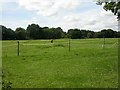
Crab Orchard, paddocks
Much of former agricultural land South of Verwood is now used as paddocks; as seen from Image
Image: © Mike Faherty
Taken: 14 Aug 2009
0.20 miles
4
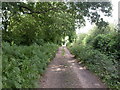
Crab Orchard Way
Bridleway from Verwood Road to Horton Farm.
Image: © Mike Faherty
Taken: 14 Aug 2009
0.24 miles