IMAGES TAKEN NEAR TO
Cranborne Road, WIMBORNE, BH21 4HW
Introduction
This page details the photographs taken nearby to Cranborne Road, BH21 4HW by members of the Geograph project.
The Geograph project started in 2005 with the aim of publishing, organising and preserving representative images for every square kilometre of Great Britain, Ireland and the Isle of Man.

There are currently over 7.5m images from over14,400 individuals and you can help contribute to the project by visiting https://www.geograph.org.uk
Image Map (Loading...)


Getting Data...Please wait
Leaflet Map data © OpenStreetMap
Images are licensed for reuse under creativecommons.org/licenses/by-sa/2.0
Notes
- Clicking on the map will re-center to the selected point.
- The higher the marker number, the further away the image location is from the centre of the postcode.
Image Listing (13 Images Found)
Images are licensed for reuse under creativecommons.org/licenses/by-sa/2.0
Image
Details
Distance
2
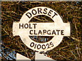
Furzehill: Clapgate signpost detail
A close-up of the finial from the original finger-post, giving location and grid reference details, which has been retained and affixed to standard modern signage. See Image for the signpost as it looks now.
Image: © Chris Downer
Taken: 7 Mar 2010
0.12 miles
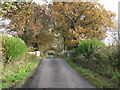
3
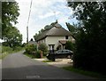
Clapgate, Crackerbox Cottage
Thatched cottage on Grange, Clapgate.
Image: © Mike Faherty
Taken: 25 Jul 2009
0.12 miles
4
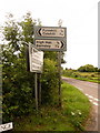
Furzehill: signs at Clapgate
These are modern signs, but the finial has been kept from the original finger-post which would once have stood here. The traditional finial gives location details (Holt - Clapgate) and six-figure grid reference.
For a close-up of the finial, see Image
Image: © Chris Downer
Taken: 18 Jul 2009
0.13 miles
5
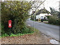
Furzehill: postbox № BH21 18, Grange
Looking southeast along Grange, past this small postbox which is emptied finally at 4pm on weekdays and at 9:30am on Saturdays.
Image: © Chris Downer
Taken: 8 Nov 2008
0.15 miles
6
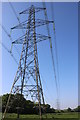
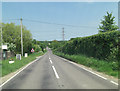
Powerlines near Higher Honeybrook Farm
These pylons are on the powerline that crosses the minor road leading from Wimborne west towards High Hall and Lower Barnsley Farm
Image: © Nigel Mykura
Taken: 18 May 2018
0.16 miles
7
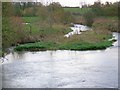
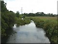
River Allen near Clapgate
Looking downstream from Fitche's Bridge.
Image: © Maigheach-gheal
Taken: 18 Nov 2009
0.22 miles
8
Furzehill: bridge over the River Allen
The lane to Barnsley crosses the River Allen by way of this little brick bridge.
Image: © Chris Downer
Taken: 8 Nov 2008
0.24 miles
9
Colehill, River Allen
As seen from Image, looking downstream. The river divides the parishes of Colehill, to the left, and Pamphill, to the right.
Image: © Mike Faherty
Taken: 25 Jul 2009
0.24 miles
10
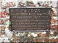
Old Bridge Marker on Fitche's Bridge, west of Clapgate
Bridge Weight Plate by the UC road, in parish of Pamphill (East Dorset District), Fitche's Bridge, mid-bridge.
Inscription reads:- : NOTICE / TO OWNERS AND DRIVERS / OF TRACTION ENGINES / THIS BRIDGE IS INSUFFICIENT / TO CARRY WEIGHTS BEYOND / THE ORDINARY TRAFFIC OF / THE DISTRICT :
Surveyed
Milestone Society National ID: DO_WEIFITbr.
Image: © Milestone Society
Taken: Unknown
0.24 miles