IMAGES TAKEN NEAR TO
Diana Way, WIMBORNE, BH21 3XJ
Introduction
This page details the photographs taken nearby to Diana Way, BH21 3XJ by members of the Geograph project.
The Geograph project started in 2005 with the aim of publishing, organising and preserving representative images for every square kilometre of Great Britain, Ireland and the Isle of Man.

There are currently over 7.5m images from over14,400 individuals and you can help contribute to the project by visiting https://www.geograph.org.uk
Image Map (Loading...)


Getting Data...Please wait
Leaflet Map data © OpenStreetMap
Images are licensed for reuse under creativecommons.org/licenses/by-sa/2.0
Notes
- Clicking on the map will re-center to the selected point.
- The higher the marker number, the further away the image location is from the centre of the postcode.
Image Listing (17 Images Found)
Images are licensed for reuse under creativecommons.org/licenses/by-sa/2.0
Image
Details
Distance
1
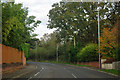
Bend on Blandford Road
A rare kink on a generally straight road.
Image: © Robin Webster
Taken: 30 Oct 2012
0.06 miles
2
Turf Zone "BlandfordWood"
At Happy Bottom Nature Reserve.
Image: © Ian S
Taken: 17 Nov 2022
0.09 miles
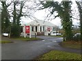
3
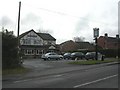
Corfe Mullen, The Mount Inn
Pub on Blandford Road. Internally, L-shaped bar with two rooms to right; pool and darts. Cask ale on offer at my visit: Ringwood Fortyniner. For some customer comments, see http://www.beerintheevening.com/pubs/s/24/24142/Mount/Corfe_Mullen
Image: © Mike Faherty
Taken: 27 Feb 2010
0.09 miles
4
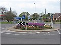
Colourful roundabout, Corfe Mullen
A mundane roundabout on Blandford Rd/Wimborne Rd, made lovely by Spring and someone's hard work, my thanks.
Image: © John Palmer
Taken: 20 Apr 2009
0.13 miles
5
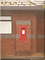
Corfe Mullen: postbox № BH21 49, Wareham Road
This George V-reign postbox, which is set into a wall on the forecourt of a petrol station, is emptied at 5pm on weekdays and at noon on Saturdays. We are looking at it through a heavyish shower of rain.
Image: © Chris Downer
Taken: 7 Jun 2009
0.18 miles
6
Corfe Mullen, Virgin Active
Health club on Wareham Road. http://www.virginactive.co.uk/clubs/east-dorset
Image: © Mike Faherty
Taken: 19 Jan 2012
0.19 miles
7
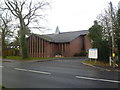
Corfe Mullen, Anglican church
The Church of St. Nicholas of Jerusalem, on Wareham Road. http://www.peterwalker.info/churches%20text/mullen.html
Image: © Mike Faherty
Taken: 19 Jan 2012
0.20 miles
8

Corfe Mullen, horse grazing
Looking from Wareham Road across grazing land; the gable of Image visible behind the field, and, beyond, the descent into the Stour valley.
Image: © Mike Faherty
Taken: 19 Jan 2012
0.21 miles
9
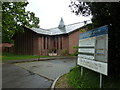
St Nicholas of Jerusalem: late May 2013
Image: © Basher Eyre
Taken: 28 May 2013
0.22 miles
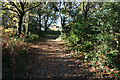
10
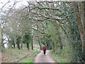
Track near Barrow Hill
No traffic, ivy-covered trees, glimpses of the heath to the South
Image: © John Palmer
Taken: 30 Mar 2009
0.23 miles