IMAGES TAKEN NEAR TO
South Road, WIMBORNE, BH21 3HY
Introduction
This page details the photographs taken nearby to South Road, BH21 3HY by members of the Geograph project.
The Geograph project started in 2005 with the aim of publishing, organising and preserving representative images for every square kilometre of Great Britain, Ireland and the Isle of Man.

There are currently over 7.5m images from over14,400 individuals and you can help contribute to the project by visiting https://www.geograph.org.uk
Image Map (Loading...)


Getting Data...Please wait
Leaflet Map data © OpenStreetMap
Images are licensed for reuse under creativecommons.org/licenses/by-sa/2.0
Notes
- Clicking on the map will re-center to the selected point.
- The higher the marker number, the further away the image location is from the centre of the postcode.
Image Listing (20 Images Found)
Images are licensed for reuse under creativecommons.org/licenses/by-sa/2.0
Image
Details
Distance
1
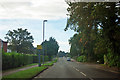
Speed camera on Warnham Road, Corfe Mullen
There is a 30 limit here. This could be an idle threat, as there are no road markings.
Image: © Robin Webster
Taken: 30 Oct 2012
0.09 miles
2
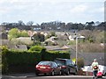
Roofs of Corfe Mullen
Taken from Wayman Road, looking North-West. The houses in the distance are fairly new and closely packed. Corfe Mullen is an overgrown dormitory village, but not a bad place to live.
Image: © John Palmer
Taken: 4 Apr 2009
0.10 miles
3
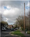
Mysterious pole, Corfe Mullen
This mysterious, tall, wooden pole appeared here recently, but what is it? There're no wires attached to it. It's a modern mobile phone aerial, disguised as a Victorian telegraph pole. What a cheek!
Image: © John Palmer
Taken: 4 Apr 2009
0.12 miles
4
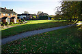
Turf Zone "Phellips"
Green off Phelipps Road, Corfe Mullen.
Image: © Ian S
Taken: 17 Nov 2022
0.12 miles
5
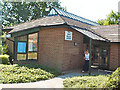
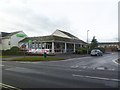
Co-op, Wareham Road, Corfe Mullen
Wareham Road is the main, straight road through the centre of Corfe Mullen. There is a large carpark behind the store.
Image: © John Palmer
Taken: 4 Apr 2009
0.13 miles
6
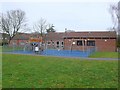
Corfe Mullen Parish Council
The parish council sits in this building located near the centre of the village in Towers way just off the Wareham Rd. It also houses the village hall.
Image: © Nigel Mykura
Taken: 31 Jan 2010
0.14 miles
7
Corfe Mullen: postbox № BH21 188, Phelipps Road
This little postbox serves a modern estate – indeed much of this large village IS modern – and is catching some late evening sunshine on this bright evening. Its final collection times are 4:30pm on weekdays and noon on Saturdays (one of only three boxes in Corfe to have a Saturday collection later than ten o'clock).
Image: © Chris Downer
Taken: 12 Jul 2009
0.14 miles
8
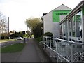
Corfe Mullen library
In Wareham Road, Corfe Mullen
Image: © David Spencer
Taken: 16 Jul 2005
0.15 miles
9
Corfe Mullen, supermarket
The Co-operative Food, on Wareham Road, at the corner of Towers Way.
Image: © Mike Faherty
Taken: 19 Jan 2012
0.15 miles
10
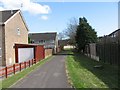
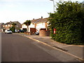
Alley in Corfe Mullen
At the end is an open grassy area. There used to be a kid's playground there,
until youths started playing there too, and the council had to remove the playground for children's safety.
Image: © John Palmer
Taken: 4 Apr 2009
0.15 miles