IMAGES TAKEN NEAR TO
Violet Farm Close, WIMBORNE, BH21 3DR
Introduction
This page details the photographs taken nearby to Violet Farm Close, BH21 3DR by members of the Geograph project.
The Geograph project started in 2005 with the aim of publishing, organising and preserving representative images for every square kilometre of Great Britain, Ireland and the Isle of Man.

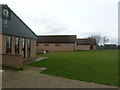
There are currently over 7.5m images from over14,400 individuals and you can help contribute to the project by visiting https://www.geograph.org.uk
Image Map
Images are licensed for reuse under creativecommons.org/licenses/by-sa/2.0
Notes
- Clicking on the map will re-center to the selected point.
- The higher the marker number, the further away the image location is from the centre of the postcode.
Image Listing (25 Images Found)
Images are licensed for reuse under creativecommons.org/licenses/by-sa/2.0
Image
Details
Distance
1
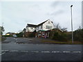
Corfe Mullen Post Office
On Blandford Road, at the corner of Badbury View Road.
Image: © Mike Faherty
Taken: 19 Jan 2012
0.05 miles
2
Corfe Mullen, milestone
On Blandford Road, at the junction with Wimborne Road, bearing the legend "POOLE / 5" and a benchmark; probably C19, erected by the Poole Turnpike Trust.
Image: © Mike Faherty
Taken: 19 Jan 2012
0.05 miles
3
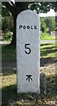
Old Milestone by the B3074, Corfe Mullen
Carved stone post by the B3074, in parish of CORFE MULLEN (EAST DORSET District), Blandford Road, Corfe Mullen, at junction of Wimborne Rd and B3074 by Lockyers Middle School, on East side of road. Dorset 2 (limestone), erected by the Blandford & Poole turnpike trust in the 19th century.
Inscription reads:-
POOLE
5
Carved benchmark front lower centre.
Milestone Society National ID: DO_POBFA05
Image: © Mike Faherty
Taken: 29 Aug 2007
0.06 miles
4
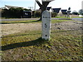
Poole 5 - Milestone on Blandford Road
Milestone Society National ID: DO_POBFA05.
Image: © JThomas
Taken: 24 Mar 2022
0.06 miles
5
Corfe Mullen, meeting halls
At the end of Badbury View Road, overlooking Corfe Mullen Recreation Ground; from the left, pre-school, guides' HQ, scouts' HQ.
Image: © Mike Faherty
Taken: 19 Jan 2012
0.06 miles
6
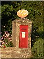
Corfe Mullen: postbox № BH21 119, Blandford Road
The postbox outside Image The little yellow patch on the collection-times plate denotes at-a-glance that there is a collection on Sundays, and therefore tells you that it is outside a post office, or a recently closed one.
Image: © Chris Downer
Taken: 2 Aug 2007
0.06 miles
7
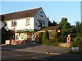
Corfe Mullen: post office
Corfe Mullen actually has two post offices – Hill View, a mile or so to the south, and this one which is actually called Corfe Mullen.
Image: © Chris Downer
Taken: 2 Aug 2007
0.06 miles
8
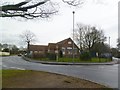
Corfe Mullen, Lockyer's Middle School
At the corner of Blandford and Wimborne Roads. The front building bears a date stone from 1897, and the side from 1860; there are modern buildings and playing fields behind. http://www.lockyersmid.dorset.sch.uk/welcome.asp
Image: © Mike Faherty
Taken: 19 Jan 2012
0.06 miles
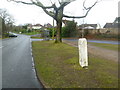
9
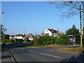
Blandford Road, Sleight
View north west up the Blandford Rd with the Wimborne Rd going off on the right and the junction with Meadowfarm Lane just visible on the left.
Image: © Nigel Mykura
Taken: 15 Nov 2011
0.06 miles
10
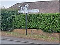
Direction Sign - Signpost on the A3074 in Corfe Mullen
Located on the southwest side of the junction of the B3074 Blandford Road and Wimborne Hill in Corfe Mullen parish. 3 arms and annulus & bar finial.
Milestone Society National ID: DO_SY9897
Image: © P Hamilton
Taken: Unknown
0.06 miles