IMAGES TAKEN NEAR TO
Park Homer Road, WIMBORNE, BH21 2SP
Introduction
This page details the photographs taken nearby to Park Homer Road, BH21 2SP by members of the Geograph project.
The Geograph project started in 2005 with the aim of publishing, organising and preserving representative images for every square kilometre of Great Britain, Ireland and the Isle of Man.

There are currently over 7.5m images from over14,400 individuals and you can help contribute to the project by visiting https://www.geograph.org.uk
Image Map
Images are licensed for reuse under creativecommons.org/licenses/by-sa/2.0
Notes
- Clicking on the map will re-center to the selected point.
- The higher the marker number, the further away the image location is from the centre of the postcode.
Image Listing (12 Images Found)
Images are licensed for reuse under creativecommons.org/licenses/by-sa/2.0
Image
Details
Distance
1
NEW
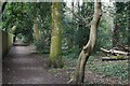
Footpath between gardens and woodland at Colehill
Image: © David Martin
Taken: 11 Mar 2025
0.08 miles
2
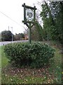
Centenary Sign, Colehill
Signpost celebrating 100 years of Colehill Parish Council, 1896 - 1996.
Image: © Lorraine and Keith Bowdler
Taken: 27 Mar 2010
0.11 miles
3
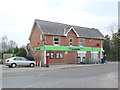
The Co-op, Colehill
This building as well as housing the co-operative shop also houses the post office. On the wall are the Parish notice board and the Colehill notice boards.
Image: © Nigel Mykura
Taken: 28 Mar 2013
0.14 miles
4
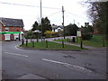
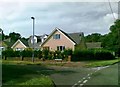
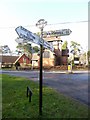
Colehill Crossroads
The crossroads of Middlehill Road, Wimborne Road and Lonnen Road in Colehill.
Image: © Lorraine and Keith Bowdler
Taken: 27 Mar 2010
0.14 miles
5
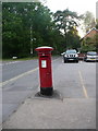
Colehill: postbox № BH21 68, Smuggler?s Lane
This George VI-reign postbox stands outside Colehill Post Office, on the corner of Lonnen Road. It is emptied finally at 5:15pm on weekdays and at noon on Saturdays.
Image: © Chris Downer
Taken: 24 Jun 2009
0.14 miles
6
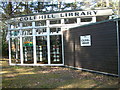
Colehill Library, Colehill, Dorset
This library is found on the edge of Colehill in amongst a group of fir trees.
Image: © Stuart Buchan
Taken: 19 Mar 2006
0.20 miles
8
Colehill: detail of Colehill Church finger-post
A close-up of the finial of the finger-post (see Image), giving location and grid reference details.
Image: © Chris Downer
Taken: 7 Mar 2010
0.23 miles
9
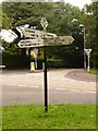
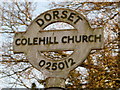
Colehill: finger-post at the church crossroads
One of numerous signposts which retain the original Dorset finial, giving location (Colehill Church in this case) and six-figure grid reference.
The fingers are, however, replacements; the originals would have been rounded rather than pointed, such as at the nearby Image
For a close-up of the finial, see Image
Image: © Chris Downer
Taken: 13 Jul 2009
0.24 miles
10
Old Direction Sign - Signpost by Colehill Lane, Colehill
Annulus and bar finial - 4 arms; Dorset halo with NGR by the UC road, in parish of Colehill (East Dorset District), on verge opposite Colehill Church, at crossroads junction of Colehill Lane with Smugglers' Lane - UC roads to Clapgate and Canford Bottom.
Surveyed
Milestone Society National ID: DO_SU0201A
Image: © Milestone Society
Taken: Unknown
0.24 miles