IMAGES TAKEN NEAR TO
Pilford Heath Road, WIMBORNE, BH21 2NB
Introduction
This page details the photographs taken nearby to Pilford Heath Road, BH21 2NB by members of the Geograph project.
The Geograph project started in 2005 with the aim of publishing, organising and preserving representative images for every square kilometre of Great Britain, Ireland and the Isle of Man.

There are currently over 7.5m images from over14,400 individuals and you can help contribute to the project by visiting https://www.geograph.org.uk
Image Map
Images are licensed for reuse under creativecommons.org/licenses/by-sa/2.0
Notes
- Clicking on the map will re-center to the selected point.
- The higher the marker number, the further away the image location is from the centre of the postcode.
Image Listing (3 Images Found)
Images are licensed for reuse under creativecommons.org/licenses/by-sa/2.0
Image
Details
Distance
1
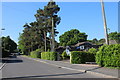
Houses on Pilford Heath Rd
This part of Wimborne is very leafy and the large gardens often contain some of the large old pine trees that were here before the houses were built.
Image: © Nigel Mykura
Taken: 18 May 2018
0.20 miles
2
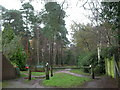
Cannon Hill, entrance
The western entrance to Cannon Hill Plantation, on Cannon Hill Road.
Image: © Mike Faherty
Taken: 2 Dec 2009
0.22 miles
3
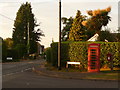
Colehill: postbox № BH21 127 and phone, Sandy Lane
By this time of the evening, the postbox is fully in the shade of its telephone box neighbour. The postbox is emptied finally at 5:15pm on weekdays and at noon on Saturdays.
Image: © Chris Downer
Taken: 24 Jun 2009
0.25 miles