IMAGES TAKEN NEAR TO
Wimborne Road West, WIMBORNE, BH21 2DY
Introduction
This page details the photographs taken nearby to Wimborne Road West, BH21 2DY by members of the Geograph project.
The Geograph project started in 2005 with the aim of publishing, organising and preserving representative images for every square kilometre of Great Britain, Ireland and the Isle of Man.

There are currently over 7.5m images from over14,400 individuals and you can help contribute to the project by visiting https://www.geograph.org.uk
Image Map
Images are licensed for reuse under creativecommons.org/licenses/by-sa/2.0
Notes
- Clicking on the map will re-center to the selected point.
- The higher the marker number, the further away the image location is from the centre of the postcode.
Image Listing (18 Images Found)
Images are licensed for reuse under creativecommons.org/licenses/by-sa/2.0
Image
Details
Distance
1
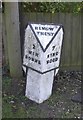
Old Milepost by Wimborne Road, Wimborne Minster
Cast iron post by the UC road, in parish of FERNDOWN TOWN (EAST DORSET District), Wimborne Road, East of bypass roundabout, by No. 210/212, by the road, on South side of road. Ringwood cast iron post (Trust), erected by the Ringwood, Longham & Leigh turnpike trust in the 19th century.
Inscription reads:- : 2 / WIM- / BORNE : : RINGW'D / TRUST : : 7 / RING- / WOOD :
Milestone Society National ID: DO_WBRW02.
Image: © J Tybjerg
Taken: 15 Jul 2002
0.01 miles
2
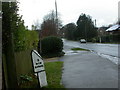
Stapehill, milepost
On Wimborne Road West, now unclassified but previously A31. Legend on the right face reads "7 / RING- / WOOD", and on the top "RINGW'D / TRUST". Of a type familiar locally, cast by Armfields of Ringwood.
Image: © Mike Faherty
Taken: 29 Nov 2009
0.01 miles
3
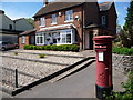
Stapehill: postbox № BH21 76, Wimborne Road West
This postbox remains in use although the post office, in the house behind, closed in 2008. See Image for the post office a year or so before closure.
Image: © Chris Downer
Taken: 27 May 2013
0.05 miles
4
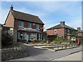
Stapehill: the post office
The post office closed in November 2008 and is now a private house.
Image: © Chris Downer
Taken: 27 Aug 2007
0.07 miles
5
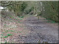
Line of Castleman Railway, Stapehill
This section of the former Southampton to Dorchester railway is signposted as a bridleway but is not marked on the map as such.
Image: © Lorraine and Keith Bowdler
Taken: 27 Mar 2010
0.10 miles
6
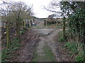
Farm Crossing of Castleman Railway, Stapehill
Image: © Lorraine and Keith Bowdler
Taken: 27 Mar 2010
0.12 miles
7
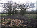
Line of Castleman Railway, Stapehill
The busy Canford Bottom roundabout is just beyond the trees to the left.
Image: © Lorraine and Keith Bowdler
Taken: 27 Mar 2010
0.13 miles
8
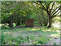
Disused mainline
A wooden shed stands in the middle of the formation that was once the mainline railway between London Waterloo and Weymouth. A low embankment is all that remains to remind us of its past history.
Image: © Peter Kazmierczak
Taken: 13 May 2015
0.16 miles
9
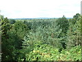
Cannon Hill
View looking north east. Taken from tumulus near Canford Bottom at grid reference SU 045 009
Image: © John Smitten
Taken: 28 Jul 2005
0.17 miles