IMAGES TAKEN NEAR TO
Hardy Crescent, WIMBORNE, BH21 2AR
Introduction
This page details the photographs taken nearby to Hardy Crescent, BH21 2AR by members of the Geograph project.
The Geograph project started in 2005 with the aim of publishing, organising and preserving representative images for every square kilometre of Great Britain, Ireland and the Isle of Man.

There are currently over 7.5m images from over14,400 individuals and you can help contribute to the project by visiting https://www.geograph.org.uk
Image Map
Images are licensed for reuse under creativecommons.org/licenses/by-sa/2.0
Notes
- Clicking on the map will re-center to the selected point.
- The higher the marker number, the further away the image location is from the centre of the postcode.
Image Listing (29 Images Found)
Images are licensed for reuse under creativecommons.org/licenses/by-sa/2.0
Image
Details
Distance
1

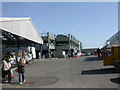
Wimborne Market
Taking place on Fridays, Saturdays & Sundays; farmer's market, plants, car boot sale, general goods, mainly in 5 covered halls. For information, see http://www.wimbornemarket.co.uk/aboutus.htm
Image: © Mike Faherty
Taken: 15 Mar 2009
0.08 miles
2
Wimborne Market, car park
Three storey car park; for information about the market, see http://www.wimbornemarket.co.uk/aboutus.htm
Image: © Mike Faherty
Taken: 15 Mar 2009
0.09 miles
3

Wimborne Minster: postbox № BH21 518, Riverside Business Park
This postbox is emptied at 6:30pm on weekdays and at noon on Saturdays – stamped mail goes in the left-hand slot and franked items in the right.
Image: © Chris Downer
Taken: 10 Jun 2009
0.12 miles
4
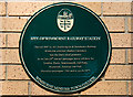
No. 12 (of 12) the Green Plaques of Wimborne - site of Wimborne Railway Station
Location: at the entrance to the Riverside Park Industrial Estate the plaque is on the wall of the modern industrial unit "Allsorts" at the 'T' junction.
Image
Image: © Mike Searle
Taken: 25 Mar 2015
0.12 miles
5
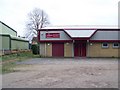
Scout Hut, Wimborne
Home of the 2nd Wimborne Scouts.
Image: © Maigheach-gheal
Taken: 11 Jan 2009
0.13 miles
6

Wimborne - site of Wimborne Railway Station
The first railway station in Dorset was built on this site in 1847 having been promoted by Charles Castleman of Allendale House. Image The line between Southampton and Dorchester was popularly known as "Castleman's Corkscrew" because of the number of route deviations necessary in order to include Wimborne as a main station on the route. The station was closed to passenger traffic in 1964 after the Beeching Act, followed by the goods trains in 1977. The industrial unit in the photo was built on the site of the old station, opposite which is a tree lined section of the old railway embankment. The Wimborne Market complex beyond was built on the site of the goods yard.
Image
Image: © Mike Searle
Taken: 25 Mar 2015
0.13 miles
7
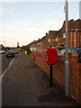
Wimborne Minster: postbox № BH21 197, Churchill Road
Looking along Churchill Road, the southern arm of a small council estate which encircles Wimborne Rugby Club's ground. The postbox is emptied finally at 5:15pm on weekdays and at 11am on Saturdays.
Image: © Chris Downer
Taken: 10 Jun 2009
0.14 miles
8
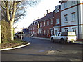
"River Views", Wimborne, Dorset
A new development on the former Cobham factory site, next to the River Stour.
Image: © Jules
Taken: 15 Apr 2015
0.14 miles
9
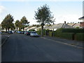
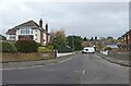
Wimborne, Barnes Crescent
1930s-looking bungalows.
Image: © Mike Faherty
Taken: 25 Oct 2009
0.16 miles