IMAGES TAKEN NEAR TO
Julians Road, WIMBORNE, BH21 1EQ
Introduction
This page details the photographs taken nearby to Julians Road, BH21 1EQ by members of the Geograph project.
The Geograph project started in 2005 with the aim of publishing, organising and preserving representative images for every square kilometre of Great Britain, Ireland and the Isle of Man.

There are currently over 7.5m images from over14,400 individuals and you can help contribute to the project by visiting https://www.geograph.org.uk
Image Map
Images are licensed for reuse under creativecommons.org/licenses/by-sa/2.0
Notes
- Clicking on the map will re-center to the selected point.
- The higher the marker number, the further away the image location is from the centre of the postcode.
Image Listing (176 Images Found)
Images are licensed for reuse under creativecommons.org/licenses/by-sa/2.0
Image
Details
Distance
1
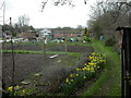
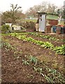
Wimborne, allotments
Off Julian's Road, alongside the Leaze.
Image: © Mike Faherty
Taken: 5 Apr 2010
0.02 miles
3
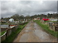
Wimborne, footpath
On the Stour Valley Way, this section of path crosses allotments before reaching Cowgrove Road.
Image: © Mike Faherty
Taken: 5 Apr 2010
0.06 miles
4
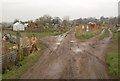
Allotments, Wimborne Minster
Footpath E2/8 crosses Old Road Allotments along the central track. It's gloomy, wet and muddy, and a kind middle-aged woman, obviously fearful for my camera, has just warned me that she fell over on the path along the river.
Image: © Derek Harper
Taken: 27 Jan 2010
0.08 miles
5
Allotment shed, Wimborne Minster
Every set of allotments has its share of quaint sheds, and Old Road Allotments, close to the River Stour in Wimborne Minster and also shown in Image, is no exception. The abandoned coal frame seems to have become a patio.
Image: © Derek Harper
Taken: 27 Jan 2010
0.09 miles
6
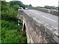
Julian's Bridge, Wimborne, (north side)
This shows the original 1636 , north side of the bridge and the roadway. There is no pavement, but the bridge is corbelled with pointed refuges in the brick parapet where pedestrians can shelter from the traffic.
Image: © Nigel Mykura
Taken: 12 Aug 2009
0.09 miles
8
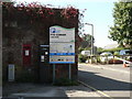
Wimborne Minster: postbox № BH21 6, Pye Corner
This George V-reign wall box is at Pye Corner, next to a small car park whose ticket machine is to its immediate right.
Image: © Chris Downer
Taken: 21 Sep 2008
0.10 miles
9
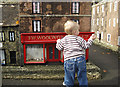
Woolworths sell big boys' toys
But not any more - they ceased trading in January 2009. This shop is a scaled down replica in Wimborne's model town.
Image: © michael ely
Taken: 31 Oct 2009
0.10 miles
10
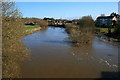
River Stour in spate
Interestingly although the rest of the day was fine, the following day the river appears to be a bit higher Image
Image: © David Lally
Taken: 4 Apr 2010
0.10 miles