IMAGES TAKEN NEAR TO
Allens Road, POOLE, BH16 5BU
Introduction
This page details the photographs taken nearby to Allens Road, BH16 5BU by members of the Geograph project.
The Geograph project started in 2005 with the aim of publishing, organising and preserving representative images for every square kilometre of Great Britain, Ireland and the Isle of Man.

There are currently over 7.5m images from over14,400 individuals and you can help contribute to the project by visiting https://www.geograph.org.uk
Image Map
Images are licensed for reuse under creativecommons.org/licenses/by-sa/2.0
Notes
- Clicking on the map will re-center to the selected point.
- The higher the marker number, the further away the image location is from the centre of the postcode.
Image Listing (12 Images Found)
Images are licensed for reuse under creativecommons.org/licenses/by-sa/2.0
Image
Details
Distance
1
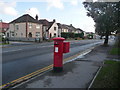
Hamworthy: postbox № BH16 170, Blandford Road
This George V-reign postbox is emptied finally at 5:30pm on weekdays and at 11:45am on Saturdays.
Image: © Chris Downer
Taken: 15 Nov 2009
0.13 miles
2
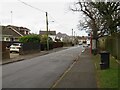
Sandy Lane, Upton, near Poole
Sandy Lane is a minor road in Upton, near Poole. The road is served by buses, as shown by the bus stops either side of the road.
Image: © Malc McDonald
Taken: 6 Feb 2022
0.14 miles
3
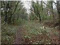
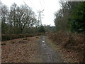
Hamworthy, dismantled railway
Overgrown trackbed of the Poole to Wimborne railway ("Castleman's Corkscrew"), closed 1964; the embankments on each side can still be detected. http://homepage.ntlworld.com/ron.strutt/rrcor2.html
Image: © Mike Faherty
Taken: 28 Feb 2010
0.15 miles
4
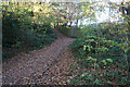
Turf Zone "AllensFactory"
Former railway line at Upton.
Image: © Ian S
Taken: 17 Nov 2022
0.16 miles
5
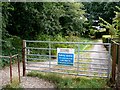
Upton Country Park
Near the western entrance, from Factory Road. http://www.boroughofpoole.com/go.php?structureID=categories&ref=C4648540DEA798
Image: © Mike Faherty
Taken: 28 Feb 2010
0.16 miles
6

Turf Zone "UptonTrailway"
Former railway line at Upton.
Image: © Ian S
Taken: 17 Nov 2022
0.17 miles
7
Ropers Lane
This is an old track that runs south from the end of Ropers lane which itself runs south of the Poole Rd just east of Upton. The gate is about 40m south of the northern edge of the grid square.
Image: © Nigel Mykura
Taken: 29 Jul 2010
0.17 miles
8
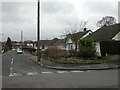
Hamworthy, Willow Close
Short road between Blandford and Allens Road, with 1930s-looking bungalows.
Image: © Mike Faherty
Taken: 28 Feb 2010
0.19 miles
9
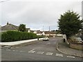
Peters Close, Upton, near Poole
Peters Close is a residential cul-de-sac in Upton, near Poole.
Image: © Malc McDonald
Taken: 6 Feb 2022
0.21 miles
10
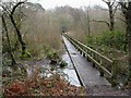
Upton, boardwalk
Boardwalk and footbridge over a stream rising on Upton Heath, and associated wetlands; in the south-western corner of Upton Country Park. http://www.boroughofpoole.com/go.php?structureID=categories&ref=C4648540DEA798
Image: © Mike Faherty
Taken: 28 Feb 2010
0.22 miles