IMAGES TAKEN NEAR TO
Freshwater Drive, POOLE, BH15 4HG
Introduction
This page details the photographs taken nearby to Freshwater Drive, BH15 4HG by members of the Geograph project.
The Geograph project started in 2005 with the aim of publishing, organising and preserving representative images for every square kilometre of Great Britain, Ireland and the Isle of Man.

There are currently over 7.5m images from over14,400 individuals and you can help contribute to the project by visiting https://www.geograph.org.uk
Image Map
Images are licensed for reuse under creativecommons.org/licenses/by-sa/2.0
Notes
- Clicking on the map will re-center to the selected point.
- The higher the marker number, the further away the image location is from the centre of the postcode.
Image Listing (6 Images Found)
Images are licensed for reuse under creativecommons.org/licenses/by-sa/2.0
Image
Details
Distance
1
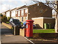
Hamworthy: postbox № BH15 8, Dawkins Road
This large Elizabeth II-reign postbox is emptied finally at 5:30pm on weekdays and at 12:30pm on Saturdays.
Image: © Chris Downer
Taken: 15 Nov 2009
0.16 miles
2
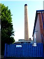
Factory Chimney
This factory chimney is part of the site that is Crown Closures. The whole site of 2.9ha is being considered for redevelopment which will mostly be residential.
Image: © Nigel Mykura
Taken: 1 Oct 2011
0.19 miles
3
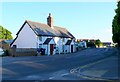
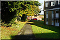
Lake Rd Hamworthy
These old cottages are on Lake Rd close to the junction with Hoyal Rd. The trees on the right of the image are some of those surrounding the Crown Closures site which is probably going to be redeveloped for residential use.
Image: © Nigel Mykura
Taken: 28 Sep 2011
0.21 miles
5

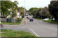
Hamworthy Fire Station
Hamworthy Fire Station, Blandford Road, Hamworthy, Poole, Dorset.
Image: © Kevin Hale
Taken: 27 Sep 2006
0.24 miles
6
Turf Zone "Blandford"
At Harkwood Court, Hamworthy.
Image: © Ian S
Taken: 17 Nov 2022
0.25 miles