IMAGES TAKEN NEAR TO
Stone Close, POOLE, BH15 4GE
Introduction
This page details the photographs taken nearby to Stone Close, BH15 4GE by members of the Geograph project.
The Geograph project started in 2005 with the aim of publishing, organising and preserving representative images for every square kilometre of Great Britain, Ireland and the Isle of Man.

There are currently over 7.5m images from over14,400 individuals and you can help contribute to the project by visiting https://www.geograph.org.uk
Image Map
Images are licensed for reuse under creativecommons.org/licenses/by-sa/2.0
Notes
- Clicking on the map will re-center to the selected point.
- The higher the marker number, the further away the image location is from the centre of the postcode.
Image Listing (52 Images Found)
Images are licensed for reuse under creativecommons.org/licenses/by-sa/2.0
Image
Details
Distance
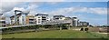
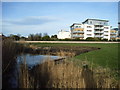
2
Modern apartments overlooking Poole Harbour
The path rises to a bridge over the disused railway tracks into Poole Docks.
Image: © David Martin
Taken: 26 Feb 2022
0.03 miles
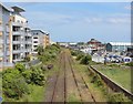
4
Disused railway tracks, Hamworthy, near Poole
Disused railway tracks leading to the ferry port at Poole. These tracks had been used for passenger trains to the original Hamworthy station, which was located in the middle distance in this image. However, the passenger trains had ceased as long ago as 1896. After that the line carried freight.
Contrasting with the disused tracks are recently-built apartment blocks. The apartments have views over Poole Harbour.
Image: © Malc McDonald
Taken: 24 Aug 2021
0.04 miles
5
Hamworthy Park 2008
The foreground shows a small water run-off onto the beach - one of the new apartment blocks at Harbour Reach in the background.
Image: © keith stuart
Taken: 2 Feb 2008
0.04 miles
6
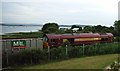
Hamworthy Railway
The old Hamworthy Branch of L.& S.W.R. at Lower Hamworthy is still used about once a week by a goods train. The locomotive seems to advance towards the Ferry Port - decouple - return on the other track towards the rear of the stock - switch to the original track in order to pick up the rolling stock and reverse direction.
The locomotive in the photo is the "Vale of Pickering".
Image: © keith stuart
Taken: 31 Jul 2008
0.05 miles
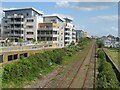
7
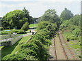
Disused railway tracks, Hamworthy, near Poole
A disused railway line which had previously used by freight trains to and from the ferry port at Poole. Although the line was disused when this image was taken, the colour light signals were still operational - look for a red light peeping through foliage near the set of points.
Image: © Malc McDonald
Taken: 24 Aug 2021
0.06 miles
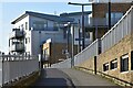
8
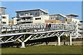
Footbridge ramp at the end of Hamworthy Park
This modern bridge connects the eastern end of the park with the town centre. The bridge and flats overlook the disused railway tracks into Poole docks.
Image: © David Martin
Taken: 26 Feb 2022
0.07 miles
9
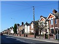
Blandford Rd Hamworthy
Very close to the docks and ferry port this road is one of the main thoroughfares of the port area. This is close to the junction with Ivor Rd.
Image: © Nigel Mykura
Taken: 28 Sep 2011
0.09 miles
10
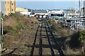
Disused railway tracks into Poole Docks
Image: © David Martin
Taken: 26 Feb 2022
0.09 miles