IMAGES TAKEN NEAR TO
Woodlands Crescent, POOLE, BH15 4EN
Introduction
This page details the photographs taken nearby to Woodlands Crescent, BH15 4EN by members of the Geograph project.
The Geograph project started in 2005 with the aim of publishing, organising and preserving representative images for every square kilometre of Great Britain, Ireland and the Isle of Man.

There are currently over 7.5m images from over14,400 individuals and you can help contribute to the project by visiting https://www.geograph.org.uk
Image Map
Images are licensed for reuse under creativecommons.org/licenses/by-sa/2.0
Notes
- Clicking on the map will re-center to the selected point.
- The higher the marker number, the further away the image location is from the centre of the postcode.
Image Listing (26 Images Found)
Images are licensed for reuse under creativecommons.org/licenses/by-sa/2.0
Image
Details
Distance
1
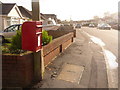
Hamworthy: postbox № BH15 249, Woodlands Avenue
This small Elizabeth II-reign postbox, clasped to a telegraph pole, is emptied finally at 5:30pm on weekdays and at 12:30pm on Saturdays.
Image: © Chris Downer
Taken: 15 Nov 2009
0.06 miles
2
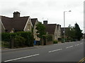
Hamworthy, Lady Wimborne's Cottages
On Blandford Road; a distinctive pattern of semi-detached cottages, built as estate cottages in the last quarter of the C19, around Poole and Wimborne.
Image: © Mike Faherty
Taken: 22 Sep 2009
0.09 miles
3
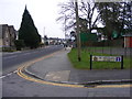
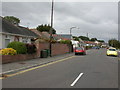
St Michaels Close
The view down Blandford Road in Hamworthy.
Image: © Gordon Griffiths
Taken: 12 Feb 2017
0.10 miles
4
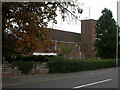
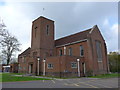
Hamworthy, St. Michael's Church
On Blandford Road, church & church centre. http://www.achurchnearyou.com/hamworthy-st-michael/
Image: © Mike Faherty
Taken: 22 Sep 2009
0.12 miles
5
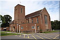
In which I Poole my resources (16)
St Michael, Hamworthy
Image: © Basher Eyre
Taken: 22 Apr 2014
0.12 miles
6
Hamworthy, bungalows
1930s bungalows in Woodlands Avenue.
Image: © Mike Faherty
Taken: 22 Sep 2009
0.13 miles
7
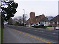
St Michaels View
The view of St Michaels Church on Blandford Road, Hamworthy.
Image: © Gordon Griffiths
Taken: 12 Feb 2017
0.13 miles
9
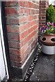
Benchmark on #26 Hinchliffe Road
Ordnance Survey cut mark benchmark described on the Bench Mark Database at http://www.bench-marks.org.uk/bm39201
Image: © Roger Templeman
Taken: 15 Aug 2011
0.14 miles
10
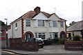
Semis on Hinchliffe Road
The left hand house, #26, has an OS benchmark Image
Image: © Roger Templeman
Taken: 15 Aug 2011
0.14 miles