IMAGES TAKEN NEAR TO
Lulworth Avenue, POOLE, BH15 4DQ
Introduction
This page details the photographs taken nearby to Lulworth Avenue, BH15 4DQ by members of the Geograph project.
The Geograph project started in 2005 with the aim of publishing, organising and preserving representative images for every square kilometre of Great Britain, Ireland and the Isle of Man.

There are currently over 7.5m images from over14,400 individuals and you can help contribute to the project by visiting https://www.geograph.org.uk
Image Map
Images are licensed for reuse under creativecommons.org/licenses/by-sa/2.0
Notes
- Clicking on the map will re-center to the selected point.
- The higher the marker number, the further away the image location is from the centre of the postcode.
Image Listing (23 Images Found)
Images are licensed for reuse under creativecommons.org/licenses/by-sa/2.0
Image
Details
Distance
1
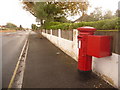
Hamworthy: postbox № BH15 179, Lulworth Avenue
This Elizabeth II-reign postbox is emptied finally at 5:30pm on weekdays and at 12:30pm on Saturdays.
Image: © Chris Downer
Taken: 15 Nov 2009
0.09 miles
2
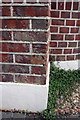
Benchmark on side of #47 Lulworth Avenue
Ordnance Survey cut mark benchmark described on the Bench Mark Database at http://www.bench-marks.org.uk/bm39199
Image: © Roger Templeman
Taken: 15 Aug 2011
0.12 miles
3
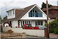
#47 Lulworth Avenue
There is an OS benchmark Image on the left side of this house
Image: © Roger Templeman
Taken: 15 Aug 2011
0.12 miles
4
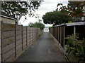
Hamworthy, footpath 13
From Branksea Avenue to Poole Harbour, at the end.
Image: © Mike Faherty
Taken: 22 Sep 2009
0.13 miles
5
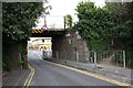
Railway bridge over Lake Road
The bridge is designated as HAG E2A/1 116m 64ch. There is an OS benchmark Image on the right buttress.
Image: © Roger Templeman
Taken: 15 Aug 2011
0.14 miles
6
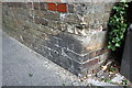
Benchmark on buttress of bridge HAG E2A/1, Lake Road
Ordnance Survey cut mark benchmark described on the Bench Mark Database at http://www.bench-marks.org.uk/bm39187
Image: © Roger Templeman
Taken: 15 Aug 2011
0.14 miles
7
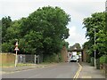
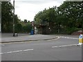
Lake Road, Poole
A low bridge carries a railway line across Lake Road in the suburbs of Poole. The railway is used occasionally for freight to and from Poole's ferry terminal, but is not used by passenger trains.
A double-deck bus can be seen in the distance beyond the bridge. The bus will turn down a side road before it reaches the bridge, as it would be too tall to pass beneath it.
Image: © Malc McDonald
Taken: 19 Jun 2023
0.14 miles
8
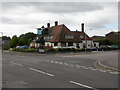
Hamworthy, The Yachtsman
Pub at the junction of Lake Road and Lake Drive. Internally, L-shaped bar, with drinking areas to left & right; cask ales on offer at my visit, Hall & Woodhouse Badger, Tanglefoot, Lemony Cricket. For some customer comments, http://www.beerintheevening.com/pubs/s/28/2890/Yachtsman/Hamworthy
Image: © Mike Faherty
Taken: 22 Sep 2009
0.14 miles
9
Hamworthy, railway bridge
Bridge carrying the now little-used Hamworthy Branch from Poole Harbour to Hamworthy Junction over Lake Road. http://www.semgonline.com/location/hamworthy-br_01.html
Image: © Mike Faherty
Taken: 22 Sep 2009
0.15 miles
10
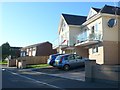
Houses in Lake Avenue
Many of the houses are built here to give views across the harbour from their balconies.
Image: © Nigel Mykura
Taken: 28 Sep 2011
0.15 miles