IMAGES TAKEN NEAR TO
Blandford Road, POOLE, BH15 4BE
Introduction
This page details the photographs taken nearby to Blandford Road, BH15 4BE by members of the Geograph project.
The Geograph project started in 2005 with the aim of publishing, organising and preserving representative images for every square kilometre of Great Britain, Ireland and the Isle of Man.

There are currently over 7.5m images from over14,400 individuals and you can help contribute to the project by visiting https://www.geograph.org.uk
Image Map
Images are licensed for reuse under creativecommons.org/licenses/by-sa/2.0
Notes
- Clicking on the map will re-center to the selected point.
- The higher the marker number, the further away the image location is from the centre of the postcode.
Image Listing (41 Images Found)
Images are licensed for reuse under creativecommons.org/licenses/by-sa/2.0
Image
Details
Distance
1
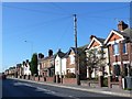
Blandford Rd Hamworthy
Very close to the docks and ferry port this road is one of the main thoroughfares of the port area. This is close to the junction with Ivor Rd.
Image: © Nigel Mykura
Taken: 28 Sep 2011
0.07 miles
2

The County Ground, home of Hamworthy United FC
Image: © nick macneill
Taken: 19 Nov 2011
0.08 miles
3
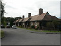
Hamworthy, cottages
On the former Carter pottery and tile factory site, off Blandford Road; a plaque states that they were built by Owen Carter in 1905 for employees.
Image: © Mike Faherty
Taken: 22 Sep 2009
0.08 miles
4
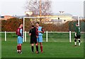
Yellow card, Hamworthy United Football Club
The game was a Wessex Premier League match between Hamworthy United and Totton and Eling FC. The yellow card led to a penalty for the away side, but Hamworthy finished winners at two goals to one.
Image: © nick macneill
Taken: 19 Nov 2011
0.09 miles
5
Junction of Moorings Close and Blandford Road
There is an OS benchmark Image on the wall pier
Image: © Roger Templeman
Taken: 15 Aug 2011
0.10 miles
6
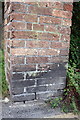
Benchmark on wall pier, Blandford Road
Ordnance Survey cut mark benchmark described on the Bench Mark Database at http://www.bench-marks.org.uk/bm39212. The whole pier can be seen at Image
Image: © Roger Templeman
Taken: 15 Aug 2011
0.10 miles
7

Through the perspex, Hamworthy United FC
For details of the match see Image]
Image: © nick macneill
Taken: 19 Nov 2011
0.10 miles
8
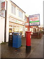
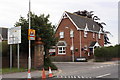
Hamworthy: postbox № BH15 20 and the old post office
One of two neighbouring shops, each now occupied by a takeaway outlet. Hamworthy Post Office was here from 2 January 1893 to 23 April 2003. The Elizabeth II-reign postbox is emptied finally at 5:30pm on weekdays and at 12:30pm on Saturdays.
Image: © Chris Downer
Taken: 15 Nov 2009
0.12 miles

10
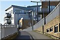
Modern apartments overlooking Poole Harbour
The path rises to a bridge over the disused railway tracks into Poole Docks.
Image: © David Martin
Taken: 26 Feb 2022
0.14 miles