IMAGES TAKEN NEAR TO
Dorchester Gardens, POOLE, BH15 3SN
Introduction
This page details the photographs taken nearby to Dorchester Gardens, BH15 3SN by members of the Geograph project.
The Geograph project started in 2005 with the aim of publishing, organising and preserving representative images for every square kilometre of Great Britain, Ireland and the Isle of Man.

There are currently over 7.5m images from over14,400 individuals and you can help contribute to the project by visiting https://www.geograph.org.uk
Image Map
Images are licensed for reuse under creativecommons.org/licenses/by-sa/2.0
Notes
- Clicking on the map will re-center to the selected point.
- The higher the marker number, the further away the image location is from the centre of the postcode.
Image Listing (7 Images Found)
Images are licensed for reuse under creativecommons.org/licenses/by-sa/2.0
Image
Details
Distance
2
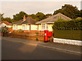
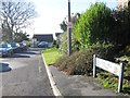
Parkstone: postbox № BH15 185, Pound Lane
A George V-reign postbox, emptied finally at 5:30pm on weekdays and at 12:30pm on Saturdays.
Image: © Chris Downer
Taken: 9 Aug 2009
0.20 miles
3

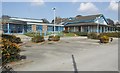
Poole, St. Mary's School
St. Mary's Catholic Combined School, at the end of Devon Road. http://www.st-marys.poole.sch.uk/
Image: © Mike Faherty
Taken: 21 Nov 2009
0.22 miles