IMAGES TAKEN NEAR TO
Staple Close Lane, POOLE, BH15 3EL
Introduction
This page details the photographs taken nearby to Staple Close Lane, BH15 3EL by members of the Geograph project.
The Geograph project started in 2005 with the aim of publishing, organising and preserving representative images for every square kilometre of Great Britain, Ireland and the Isle of Man.

There are currently over 7.5m images from over14,400 individuals and you can help contribute to the project by visiting https://www.geograph.org.uk
Image Map
Images are licensed for reuse under creativecommons.org/licenses/by-sa/2.0
Notes
- Clicking on the map will re-center to the selected point.
- The higher the marker number, the further away the image location is from the centre of the postcode.
Image Listing (20 Images Found)
Images are licensed for reuse under creativecommons.org/licenses/by-sa/2.0
Image
Details
Distance
1
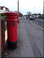
Oakdale: postbox № BH15 162, Wimborne Road
This Victorian postbox is currently missing its last-collection information plate. Today being a bank holiday, it won't receive a collection till tomorrow anyway.
Image: © Chris Downer
Taken: 28 Dec 2009
0.05 miles
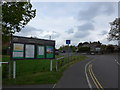
2
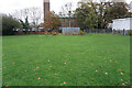
Turf Zone "StGeorgie"
St George's Playingfield, Poole.
Image: © Ian S
Taken: 16 Nov 2022
0.10 miles
4

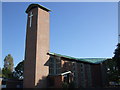
In which I Poole my resources (8)
St George, Oakdale
Image: © Basher Eyre
Taken: 22 Apr 2014
0.13 miles
5

St George, Oakley: foundation stone
Also see https://en.wikipedia.org/wiki/Maurice_Key
Image: © Basher Eyre
Taken: 22 Apr 2014
0.13 miles
6
Stanley Green First School
Sandwiched between Stanley Green and Wimborne Roads, but without a good view of the school from either entrance. http://www.stanleygreen.poole.sch.uk/
Image: © Mike Faherty
Taken: 8 Nov 2009
0.13 miles

8

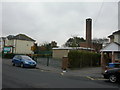
Looking from Darbys Lane into Johnston Road
Image: © Basher Eyre
Taken: 22 Apr 2014
0.14 miles
9
Approaching the junction of Darbys Lane and Trigon Road
Image: © Basher Eyre
Taken: 22 Apr 2014
0.16 miles
10
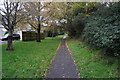
Turf Zone "Collwod"
Path alongside Dorset Way at Collwood Close, Poole.
Image: © Ian S
Taken: 16 Nov 2022
0.16 miles