IMAGES TAKEN NEAR TO
Fernside Road, POOLE, BH15 2QZ
Introduction
This page details the photographs taken nearby to Fernside Road, BH15 2QZ by members of the Geograph project.
The Geograph project started in 2005 with the aim of publishing, organising and preserving representative images for every square kilometre of Great Britain, Ireland and the Isle of Man.

There are currently over 7.5m images from over14,400 individuals and you can help contribute to the project by visiting https://www.geograph.org.uk
Image Map
Images are licensed for reuse under creativecommons.org/licenses/by-sa/2.0
Notes
- Clicking on the map will re-center to the selected point.
- The higher the marker number, the further away the image location is from the centre of the postcode.
Image Listing (32 Images Found)
Images are licensed for reuse under creativecommons.org/licenses/by-sa/2.0
Image
Details
Distance
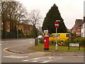
1
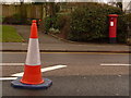
Parkstone: postbox № BH15 138, Fernside Road
This Edward VII-reign postbox stands close to the Ringwood Road/Longfleet Road junction, diagonally opposite the Shah of Persia pub, and is emptied finally at 5:30pm on weekdays and at noon on Saturdays.
The traffic lights are out of order – whether due to roadworks or to malfunction I don't know – and are currently replaced by four-way temporary lights, causing slight delays on all approaches. Hence the traffic cone in the middle of the road, blocking off the right-turn lane.
Image: © Chris Downer
Taken: 28 Feb 2010
0.05 miles
2
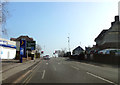
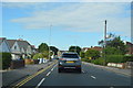
The Shah Road Junction
Approaching the busy "Shah" road junction in Poole, where the A35 crosses the B3068.
Image: © Peter Kazmierczak
Taken: 13 Mar 2016
0.09 miles
3
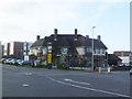
Longfleet, Shah of Persia
An imposing 1930s pub at the corner of Longfleet and Fernside Roads. Internally, four eating and drinking areas on two levels around an angular bar; TV, games machines, accommodation. Cask ales on offer at my visit: Marston's Pedigree, Ringwood Best, Wychwood Hobgoblin. Apparently bearing the name of an earlier establishment, demolished in 1931, commemorating the visit of the Shah to Poole in 1875. For some customer comments, see http://www.beerintheevening.com/pubs/s/48/4850/Shah_Of_Persia/Poole
Image: © Mike Faherty
Taken: 22 Jan 2012
0.10 miles
4
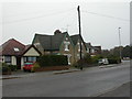
Poole, Lady Wimborne Cottages
At the junction of Longfleet and Ringwood Roads, one of two pairs of cottages (with more modern infill) built in a distinctive style as estate cottages by Lady Wimborne and her daughter, between 1867 and 1904; these are dated 1870. 111 of the model cottages are thought to have been built for Canford Estate workers. http://archive.dorsetecho.co.uk/2000/11/6/109091.html
Image: © Mike Faherty
Taken: 21 Nov 2009
0.10 miles
5
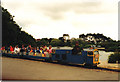
Poole Park Railway 1988
Nice to know that the trains change with the times too!
Image: © Carol Walker
Taken: Unknown
0.12 miles
6
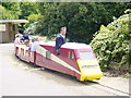
Poole Park Railway
Established in 1949. Another group of happy faces returning to the station
Image: © Colin Foot
Taken: 20 Jun 2004
0.12 miles
8
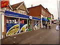
Poole: shops facing Civic Centre
These shops stand on the gyratory system which surrounds the Poole Civic Centre, Police Station and courts. The convenience store in the foreground was also Park Gates Post Office (named because the gates of Poole Park are only a short distance away) until its closure in 2008.
Image: © Chris Downer
Taken: 28 Feb 2010
0.14 miles
9
Poole: postbox № BH15 145, Parkstone Road
This large, Elizabeth II-reign postbox has been moved to this corner from outside the shops a short distance east, since the closure of Park Gates Post Office in the parade, in 2008. See also Image It is emptied finally at 5:30pm on weekdays and at 12:30pm on Saturdays.
Image: © Chris Downer
Taken: 28 Feb 2010
0.15 miles
10
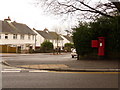
Parkstone: postbox № BH14 132, Danecourt Road
This George VI-reign postbox is emptied finally at 5:30pm on weekdays and at 11:30am on Saturdays. Fernside Avenue is to the left.
Image: © Chris Downer
Taken: 28 Feb 2010
0.15 miles