IMAGES TAKEN NEAR TO
Parkstone Road, POOLE, BH15 2PU
Introduction
This page details the photographs taken nearby to Parkstone Road, BH15 2PU by members of the Geograph project.
The Geograph project started in 2005 with the aim of publishing, organising and preserving representative images for every square kilometre of Great Britain, Ireland and the Isle of Man.

There are currently over 7.5m images from over14,400 individuals and you can help contribute to the project by visiting https://www.geograph.org.uk
Image Map
Images are licensed for reuse under creativecommons.org/licenses/by-sa/2.0
Notes
- Clicking on the map will re-center to the selected point.
- The higher the marker number, the further away the image location is from the centre of the postcode.
Image Listing (88 Images Found)
Images are licensed for reuse under creativecommons.org/licenses/by-sa/2.0
Image
Details
Distance
1
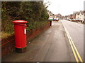
Poole: postbox № BH15 39, Parkstone Road
This large, Elizabeth II-reign postbox is emptied finally at 5:30pm on weekdays and at noon on Saturdays.
Image: © Chris Downer
Taken: 28 Feb 2010
0.01 miles
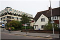
2
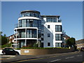
Remi Court
A block of flats at the end of Seldown Road.
Image: © Rod Allday
Taken: 2 Jul 2015
0.07 miles
3
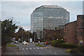
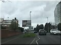
Poole : Mount Pleasant Road
Looking along Mouth Pleasant Road.
Image: © Lewis Clarke
Taken: 28 Oct 2017
0.08 miles
4
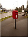
Poole: postbox № BH15 9, Mount Pleasant Road
This small postbox receives its final collections at 6:30pm on weekdays and at 12:45pm on Saturdays.
Image: © Chris Downer
Taken: 28 Feb 2010
0.09 miles
6

Race for Life 2008
The participants gather on a beautiful Sunday morning, for this year's Race for Life in Poole Park. Over 1700 runners, joggers and walkers complete a 5km circuit to raise funds for Cancer Research.
Image: © Val Pollard
Taken: 11 May 2008
0.12 miles
7
Poole Park, lodge
Park-keeper's house at Kingland Road entrance. The house is dated 1888; a plaque records the opening of the park by the Prince of Wales in 1890. For more information about the park, see http://www.boroughofpoole.com/downloads/assets/POOLE_PARK_1-32.pdf . Note the eagle perched on pillar, one of a pair; for complete view of another entrance, see Image
Image: © Mike Faherty
Taken: 13 Feb 2009
0.12 miles
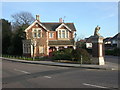
8
Longfleet URC
Former Congregational church on Longfleet Road: http://longfleeturc.org.uk/?page_id=2
Image: © Mike Faherty
Taken: 18 Sep 2012
0.12 miles
9
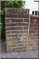
Benchmark on wall outside #52 Longfleet Road
Ordnance Survey cut mark benchmark described on the Bench Mark Database at http://www.bench-marks.org.uk/bm39210
Image: © Roger Templeman
Taken: 15 Aug 2011
0.13 miles
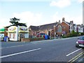
10
#52 Longfleet Road and the hospital
I don't know what the man in the pink shirt is doing: possibly looking for the OS benchmark Image on the wall of #52.
Image: © Roger Templeman
Taken: 15 Aug 2011
0.13 miles