IMAGES TAKEN NEAR TO
St. Marys Road, POOLE, BH15 2LQ
Introduction
This page details the photographs taken nearby to St. Marys Road, BH15 2LQ by members of the Geograph project.
The Geograph project started in 2005 with the aim of publishing, organising and preserving representative images for every square kilometre of Great Britain, Ireland and the Isle of Man.

There are currently over 7.5m images from over14,400 individuals and you can help contribute to the project by visiting https://www.geograph.org.uk
Image Map
Images are licensed for reuse under creativecommons.org/licenses/by-sa/2.0
Notes
- Clicking on the map will re-center to the selected point.
- The higher the marker number, the further away the image location is from the centre of the postcode.
Image Listing (32 Images Found)
Images are licensed for reuse under creativecommons.org/licenses/by-sa/2.0
Image
Details
Distance
1
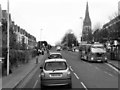
Longfleet Road
Longfleet Road (B3068) outside Poole hospital. The spire of St Mary's Church can be seen ahead.
Image: © David Dixon
Taken: 18 Dec 2012
0.06 miles
2
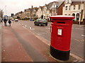
Poole: postbox № BH15 37, Longfleet Road
This double-aperture postbox stands outside the main entrance of Poole General Hospital. It is emptied finally at 5:30pm on weekdays and at noon on Saturdays.
Image: © Chris Downer
Taken: 28 Feb 2010
0.07 miles
3
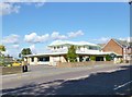
Longfleet, medical practice
Adam Medical Practice, on Longfleet Road. http://www.adampractice.co.uk/poole_surgery.htm
Image: © Mike Faherty
Taken: 18 Sep 2012
0.08 miles
4
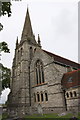
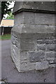
St Mary's Church, Longfleet Road
There is an OS benchmark Image on the tower buttress at the left of the picture
Image: © Roger Templeman
Taken: 15 Aug 2011
0.08 miles
5
Benchmark on buttress of St Mary's Church
Ordnance Survey cut mark benchmark described on the Bench Mark Database at http://www.bench-marks.org.uk/bm39211
Image: © Roger Templeman
Taken: 15 Aug 2011
0.08 miles
6
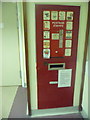
Poole: postbox within Poole Hospital
This postbox stands just inside the main entrance of Poole General Hospital, and is not a Royal Mail box. Rather, patients and visitors are allowed to post items in here and it is emptied by hospital staff to join the main outgoing bulk of mail.
The small plaque towards the bottom is identical to the one in the Gilbert Bain Hospital, Lerwick, although that latter box has been adopted by Royal Mail and bears their reference № ZE1 65. See Image
Above, surrounded by advertising, is a long-disused stamp dispensing machine. These days, with stamps available from a huge number of stockists, they can be bought from the shop counter a few yards away.
(If this were officially a Royal Mail box, it would appear on their lists and would have advertised collection times)
Image: © Chris Downer
Taken: 14 May 2014
0.08 miles
7
#70 Garland Road
House at the junction of Garland Road and Maple Road. There is an OS benchmark Image on the house wall near its junction with the front garden wall.
Image: © Roger Templeman
Taken: 23 Aug 2011
0.09 miles
8
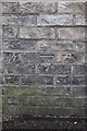
Benchmark on #70 Garland Road
Ordnance Survey cut mark benchmark described on the Bench Mark Database at http://www.bench-marks.org.uk/bm39116
Image: © Roger Templeman
Taken: 23 Aug 2011
0.09 miles
9

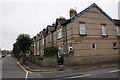
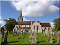
Longfleet: parish church of St. Mary
My hospital (next door) bay window had the encouraging view of the churchyard!
Image: © Chris Downer
Taken: Unknown
0.09 miles
10
Longfleet Parish Church
St. Mary's, on Longfleet Road; seen from the churchyard: http://www.smlpoole.org.uk/
Image: © Mike Faherty
Taken: 18 Sep 2012
0.09 miles