IMAGES TAKEN NEAR TO
Wimborne Road, POOLE, BH15 2BZ
Introduction
This page details the photographs taken nearby to Wimborne Road, BH15 2BZ by members of the Geograph project.
The Geograph project started in 2005 with the aim of publishing, organising and preserving representative images for every square kilometre of Great Britain, Ireland and the Isle of Man.

There are currently over 7.5m images from over14,400 individuals and you can help contribute to the project by visiting https://www.geograph.org.uk
Image Map
Images are licensed for reuse under creativecommons.org/licenses/by-sa/2.0
Notes
- Clicking on the map will re-center to the selected point.
- The higher the marker number, the further away the image location is from the centre of the postcode.
Image Listing (29 Images Found)
Images are licensed for reuse under creativecommons.org/licenses/by-sa/2.0
Image
Details
Distance
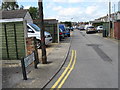
1
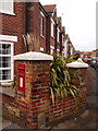
Poole: postbox № BH15 32, Heckford Road
This Elizabeth II-reign postbox is of a design more commonly found mounted on a post or strapped to a telegraph pole, but in this case it has been set into a brick pillar on the corner of St. John's Road, along which we are looking.
It is emptied finally at 5:30pm on weekdays and at noon on Saturdays.
Image: © Chris Downer
Taken: 28 Dec 2009
0.06 miles
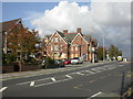
2
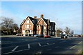
Tatnam Public House
This large pub is on the west side of the Wimborne Rd the B3093 in Longfleet.
Image: © Nigel Mykura
Taken: 14 Feb 2009
0.08 miles
3
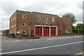
Poole Fire Station
Poole Fire Station, Wimborne Road, Poole, Dorset.
Image: © Kevin Hale
Taken: 27 Sep 2006
0.08 miles
4
Poole Meeting House
The meeting house of Poole and Wimborne Quakers, on Wimborne Road. http://www.freewebs.com/poolequakers/
Image: © Mike Faherty
Taken: 29 Oct 2009
0.10 miles
6
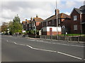
Poole, The Tatnam
At the junction of Wimborne and Tatnam Roads; since Image was taken, the pub has closed, and is now boarded up. No more "live music" or "accommodation".
Image: © Mike Faherty
Taken: 29 Oct 2009
0.11 miles
7
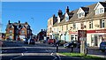
Shops at Tatnam Crescent
The road is Garland Road, but Tatnam Crescent is the curved terrace of shops and flats. The cooperative food store in the background was formerly the Tatnam Hotel public house.
Image: © David Martin
Taken: 6 Jan 2024
0.12 miles
8
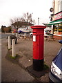
Poole: postbox № BH15 23, Wimborne Road
This Victorian postbox stands outside a terrace of shops which curves around the corner of Wimborne and Jolliffe Roads, known as Tatnam Crescent, whose frontages are rather cluttered with parked cars just now. There was a post office here, named Heckford Park, until the 1970s.
The postbox receives its final daily collections at 5:30pm on weekdays and at noon on Saturdays.
Image: © Chris Downer
Taken: 28 Dec 2009
0.13 miles
9
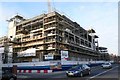
New Joint Emergency Services Building in Wimborne Road, Poole
The Joint Emergency Services Building under construction on the west side of Wimborne Road, very close to Poole Stadium. It includes a new police station, which opened to the public on 17 December 2009.
Image: © Nigel Mykura
Taken: 14 Feb 2009
0.13 miles
10

Poole Dog Track
Here the connections of Ayers Rock (out of trap 3) are waiting to collect their trophy.
Image: © michael ely
Taken: 18 May 2010
0.13 miles