IMAGES TAKEN NEAR TO
Durrell Way, POOLE, BH15 1YN
Introduction
This page details the photographs taken nearby to Durrell Way, BH15 1YN by members of the Geograph project.
The Geograph project started in 2005 with the aim of publishing, organising and preserving representative images for every square kilometre of Great Britain, Ireland and the Isle of Man.

There are currently over 7.5m images from over14,400 individuals and you can help contribute to the project by visiting https://www.geograph.org.uk
Image Map
Images are licensed for reuse under creativecommons.org/licenses/by-sa/2.0
Notes
- Clicking on the map will re-center to the selected point.
- The higher the marker number, the further away the image location is from the centre of the postcode.
Image Listing (54 Images Found)
Images are licensed for reuse under creativecommons.org/licenses/by-sa/2.0
Image
Details
Distance
1
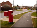
Poole: postbox № BH15 247, Newfoundland Drive
This modern postbox, serving a largely modern housing area, is emptied finally at 6:30pm on weekdays and at 12:30pm on Saturdays.
Image: © Chris Downer
Taken: 28 Feb 2010
0.06 miles
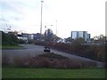
2
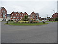
Poole : Newfoundlands Drive
A roundabout at Newfoundlands Drive in Poole.
Image: © Lewis Clarke
Taken: 13 Mar 2009
0.10 miles
3
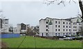
Holiday Inn Express, Poole and apartment blocks beyond
A modern budget hotel near the bus station
Image: © David Smith
Taken: 13 Feb 2016
0.11 miles
4
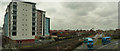
Poole : Corfe House & Railway
University owned Corfe House is beside the railway and near to a bus depot.
Image: © Lewis Clarke
Taken: 13 Mar 2009
0.11 miles
5
Before gas was dashed; when buses were green
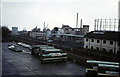
Across the Bournemouth to Weymouth railway line from the bus depot of Hants & Dorset Motor Services Ltd was Poole Gas Works. Opened in 1925 and made redundant by discovery of natural gas resources, its demolition was under way when the photograph was taken. The bus depot, which included a maintenance area as well as stabling ground, was built in the 1960s as part of a multi-storey car park and adjacent undercover shopping mall.
Image: © A-M-Jervis
Taken: 29 Jan 1972
0.12 miles
6
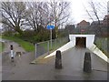
Pedestrian tunnel under railway line, south of Poole Park
A convenient link from the park to Baiter and Parkstone Bay. Cycling is (officially) banned, but the alternative for cyclists is to divert to the eastern edge of the park.
Image: © David Smith
Taken: 13 Feb 2016
0.15 miles
7
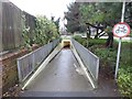
Southern entrance of pedestrian tunnel, Poole Park
The tunnel under the railway links Baiter and Parkstone Bay with Poole Park
Image: © David Smith
Taken: 13 Feb 2016
0.16 miles
8
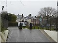
Pedestrian's eye view of Park Lake Road, Poole
Seen from the end of the footway tunnel under the railway line
Image: © David Smith
Taken: 13 Feb 2016
0.16 miles
9
Poole : Seldown Bridge
There is a construction taking place and also Corfe House, which is Bournemouth University's halls of residence.
Image: © Lewis Clarke
Taken: 7 Dec 2007
0.17 miles
10
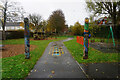
Turf Zone "PlayItGreen"
Park off Green Gardens (road), Poole.
Image: © Ian S
Taken: 16 Nov 2022
0.18 miles