IMAGES TAKEN NEAR TO
Waldren Close, POOLE, BH15 1XS
Introduction
This page details the photographs taken nearby to Waldren Close, BH15 1XS by members of the Geograph project.
The Geograph project started in 2005 with the aim of publishing, organising and preserving representative images for every square kilometre of Great Britain, Ireland and the Isle of Man.

There are currently over 7.5m images from over14,400 individuals and you can help contribute to the project by visiting https://www.geograph.org.uk
Image Map
Images are licensed for reuse under creativecommons.org/licenses/by-sa/2.0
Notes
- Clicking on the map will re-center to the selected point.
- The higher the marker number, the further away the image location is from the centre of the postcode.
Image Listing (43 Images Found)
Images are licensed for reuse under creativecommons.org/licenses/by-sa/2.0
Image
Details
Distance
1
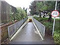
Southern entrance of pedestrian tunnel, Poole Park
The tunnel under the railway links Baiter and Parkstone Bay with Poole Park
Image: © David Smith
Taken: 13 Feb 2016
0.06 miles
2
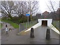
Pedestrian tunnel under railway line, south of Poole Park
A convenient link from the park to Baiter and Parkstone Bay. Cycling is (officially) banned, but the alternative for cyclists is to divert to the eastern edge of the park.
Image: © David Smith
Taken: 13 Feb 2016
0.07 miles
3
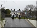
Pedestrian's eye view of Park Lake Road, Poole
Seen from the end of the footway tunnel under the railway line
Image: © David Smith
Taken: 13 Feb 2016
0.09 miles
4

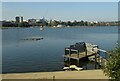
Bournemouth to Wareham Railway
Poole high rise flats, hospital and housing estates in the distance. On the right through the trees is Poole Park Boating Lake. On the left, now covered with grass, is an infill where the water of the Harbour used to come close to the railway line. In the bottom right corner, the line crosses a road with a narrow bridge Image, beware of getting splashed by cars!
Image: © John Palmer
Taken: 9 Sep 2009
0.13 miles
5
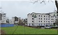
Holiday Inn Express, Poole and apartment blocks beyond
A modern budget hotel near the bus station
Image: © David Smith
Taken: 13 Feb 2016
0.13 miles
6
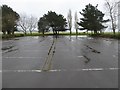
Flooded car park on Baiter recreation ground, Poole
Image: © David Smith
Taken: 13 Feb 2016
0.14 miles
7
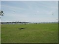
Harbourside Park, Poole
Harbourside Park, as the name suggests, is located next to Poole Harbour. Even in good weather, it is windy so very popular for kite flying.
Image: © GaryReggae
Taken: 1 Jul 2006
0.14 miles
8
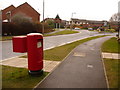
Poole: postbox № BH15 247, Newfoundland Drive
This modern postbox, serving a largely modern housing area, is emptied finally at 6:30pm on weekdays and at 12:30pm on Saturdays.
Image: © Chris Downer
Taken: 28 Feb 2010
0.14 miles
10
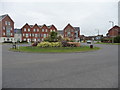
Poole : Newfoundlands Drive
A roundabout at Newfoundlands Drive in Poole.
Image: © Lewis Clarke
Taken: 13 Mar 2009
0.19 miles