IMAGES TAKEN NEAR TO
Emerson Road, POOLE, BH15 1QS
Introduction
This page details the photographs taken nearby to Emerson Road, BH15 1QS by members of the Geograph project.
The Geograph project started in 2005 with the aim of publishing, organising and preserving representative images for every square kilometre of Great Britain, Ireland and the Isle of Man.

There are currently over 7.5m images from over14,400 individuals and you can help contribute to the project by visiting https://www.geograph.org.uk
Image Map
Images are licensed for reuse under creativecommons.org/licenses/by-sa/2.0
Notes
- Clicking on the map will re-center to the selected point.
- The higher the marker number, the further away the image location is from the centre of the postcode.
Image Listing (227 Images Found)
Images are licensed for reuse under creativecommons.org/licenses/by-sa/2.0
Image
Details
Distance
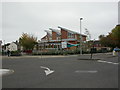
1

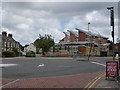
Would you dare drive down here?
Although a one-way street being a dead-end appears somewhat incongruous, the signs are in fact accurate. I'll leave those of you brave enough to drive down there to discover how it works.
Image: © Chris Downer
Taken: Unknown
0.07 miles
2
Poole: Old Town First School modern extension
This school was originally (well, formerly) South Road Combined School (Combined denoting that it covers the age range of both first and middle schools). A reorganisation amalgamated it partly with Oakdale to become Oakdale South Road Combined on an Oakdale site, leaving this school to serve only the first-school age group. The original building is still standing beyond this brand new building, which we are looking at from across Lagland Street.
Image: © Chris Downer
Taken: 19 Jul 2009
0.07 miles
3
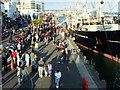
Poole Quay
Motorcycle meeting, Poole Quay Dream Machines
Image: © Malcolm Grant
Taken: 14 Jun 2005
0.08 miles
4
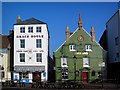
Grace House & Poole Arms
Two of the interesting old buildings on Poole Quay.
Image: © Stephen Nunney
Taken: Unknown
0.08 miles
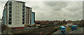
5
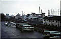
Before gas was dashed; when buses were green
Across the Bournemouth to Weymouth railway line from the bus depot of Hants & Dorset Motor Services Ltd was Poole Gas Works. Opened in 1925 and made redundant by discovery of natural gas resources, its demolition was under way when the photograph was taken. The bus depot, which included a maintenance area as well as stabling ground, was built in the 1960s as part of a multi-storey car park and adjacent undercover shopping mall.
Image: © A-M-Jervis
Taken: 29 Jan 1972
0.09 miles
6
Poole, first school
Old Town First School and Nursery, on Lagland Street. The original building is out of sight, behind the modern. http://www.oldtown.poole.sch.uk/pages/about-us.php
Image: © Mike Faherty
Taken: 4 Nov 2010
0.09 miles
7
Poole : Corfe House & Railway
University owned Corfe House is beside the railway and near to a bus depot.
Image: © Lewis Clarke
Taken: 13 Mar 2009
0.09 miles
8
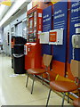
Poole: postbox № BH15 ??,within Sainsbury?s
I cannot give the number of this postbox because it appears to have escaped an appearance on the Royal Mail's list of boxes. It is emptied finally at 2:45pm on weekdays and at noon on Saturdays.
Image: © Chris Downer
Taken: 19 Jul 2009
0.11 miles
9
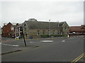
Poole Christian Fellowship
Evangelical church on Lagland Street, with a datestone of 1890, when it was built as a Brethren's Hall. http://www.poolechristianfellowship.org/
Image: © Mike Faherty
Taken: 4 Nov 2010
0.11 miles
10
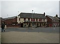
Poole, The Foundry Arms
Pub on Lagland Street. Internally, bar at back, eating and drinking areas to left, front and right; TV, music, games area (darts, pool), patio. Cask ales on offer at my visit: Ringwood Best, Fortyniner. For some customer comments, see http://www.beerintheevening.com/pubs/s/55/5509/Foundry/Poole
Image: © Mike Faherty
Taken: 4 Nov 2010
0.11 miles