IMAGES TAKEN NEAR TO
Links Road, POOLE, BH14 9QR
Introduction
This page details the photographs taken nearby to Links Road, BH14 9QR by members of the Geograph project.
The Geograph project started in 2005 with the aim of publishing, organising and preserving representative images for every square kilometre of Great Britain, Ireland and the Isle of Man.

There are currently over 7.5m images from over14,400 individuals and you can help contribute to the project by visiting https://www.geograph.org.uk
Image Map
Images are licensed for reuse under creativecommons.org/licenses/by-sa/2.0
Notes
- Clicking on the map will re-center to the selected point.
- The higher the marker number, the further away the image location is from the centre of the postcode.
Image Listing (17 Images Found)
Images are licensed for reuse under creativecommons.org/licenses/by-sa/2.0
Image
Details
Distance
1
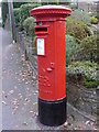
Canford Cliffs: Edward VIII postbox, Links Road
A close-up of Image, this is one of only about 150 Edward VIII-reign boxes remaining in use. There is another a mile or so west.
Image: © Chris Downer
Taken: 10 Jan 2009
0.04 miles
2
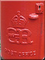
Canford Cliffs: Edward VIII postbox cipher
Image: © Chris Downer
Taken: 10 Jan 2009
0.04 miles
3
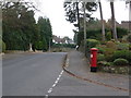
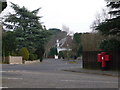
Canford Cliffs: postbox № BH14 197, Links Road
This is a very rare survival – one of only about 150 surviving boxes with the cipher of Edward VIII. Beyond, the right-hand pavement is raised slightly from the road. The box is emptied finally at 5:30pm on weekdays and noon on Saturdays.
For a closer look, see Image and Image
Image: © Chris Downer
Taken: 10 Jan 2009
0.05 miles
4
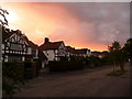
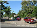
Canford Cliffs: Widdicombe Avenue
Widdicombe Avenue is in an area of very desirable, upmarket housing and is unusual in having an intermittent little central reservation planted with small trees. A splendid orange sky hints at the good weather of the evening, but not the whole day which was drizzly till teatime.
Image: © Chris Downer
Taken: 5 Aug 2009
0.06 miles
5
Widdicombe Avenue, near Poole
Widdicombe Avenue is a residential road near Poole.
Image: © Malc McDonald
Taken: 25 Aug 2021
0.09 miles
6
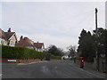
Canford Cliffs: postbox № BH14 167, Canford Cliffs Avenue
This George V-reign postbox is in a funny little road, Canford Cliffs Avenue, which has a sort of central reservation running through it – as seen through to the distance – though interrupted opposite each driveway so residents can turn in either direction. Widdicombe Avenue, off to the right, does likewise.
This postbox has two drop boxes (see below) attached.
Image: © Chris Downer
Taken: 10 Jan 2009
0.09 miles
7
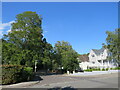
Canford Cliffs Avenue, near Poole
Canford Cliffs Avenue is a residential road near Poole.
The house to the right of the image is recently-built. At the time this image was taken, the house was not present on the Google Streetview image of this location.
Image: © Malc McDonald
Taken: 25 Aug 2021
0.10 miles
8
Parkstone: postbox № BH14 151, Clifton Road
A George V-reign box by the junction with King's Crescent, emptied finally at 5:30pm on weekdays and at noon on Saturdays.
Image: © Chris Downer
Taken: 10 Jan 2009
0.15 miles
9
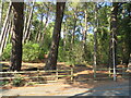
Path through trees, near Poole
A path through trees near Poole.
Image: © Malc McDonald
Taken: 25 Aug 2021
0.17 miles
10
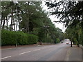
Branksome Park, Canford Cliff Road
Wide road from Branksome to Canford Cliffs. To the East (left in this picture) is the boundary of Branksome Park Conservation Area.
Image: © Mike Faherty
Taken: 23 Sep 2009
0.19 miles