IMAGES TAKEN NEAR TO
Penn Hill Avenue, POOLE, BH14 9NA
Introduction
This page details the photographs taken nearby to Penn Hill Avenue, BH14 9NA by members of the Geograph project.
The Geograph project started in 2005 with the aim of publishing, organising and preserving representative images for every square kilometre of Great Britain, Ireland and the Isle of Man.

There are currently over 7.5m images from over14,400 individuals and you can help contribute to the project by visiting https://www.geograph.org.uk
Image Map
Images are licensed for reuse under creativecommons.org/licenses/by-sa/2.0
Notes
- Clicking on the map will re-center to the selected point.
- The higher the marker number, the further away the image location is from the centre of the postcode.
Image Listing (24 Images Found)
Images are licensed for reuse under creativecommons.org/licenses/by-sa/2.0
Image
Details
Distance
1
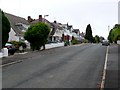
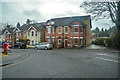
Caledon Rd Poole
View east along Caledon Rd which runs from Spur Hill Avenue to Kings Ave. Large detached houses in immaculate condition with immaculate cars outside next to immaculate lawns.
Image: © Nigel Mykura
Taken: 13 Jul 2010
0.09 miles
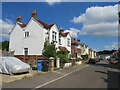
2
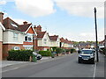
Parkstone Avenue, Penn Hill, Poole
Parkstone Avenue is a residential road in Penn Hill, a suburb of Poole.
Image: © Malc McDonald
Taken: 25 Aug 2021
0.09 miles
4
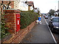
Parkstone: postbox № BH14 59, Parkstone Avenue
A George V-reign wall box outside number 105 Parkstone Avenue. The advertised last collection times are 5:30pm on weekdays and noon on Saturdays, but the postman was obviously running a little late today because he was emptying it just before I took this picture, at around 2 o'clock.
Image: © Chris Downer
Taken: 10 Jan 2009
0.13 miles
5
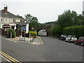
Poole : North Lodge Road
Looking along North Lodge Road off of Bournemouth Road.
Image: © Lewis Clarke
Taken: 27 Mar 2018
0.14 miles
6
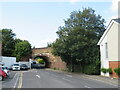
North Lodge Road, Penn Hill, near Poole
An arch bridge takes the London to Weymouth railway line across North Lodge Road, in the Penn Hill district of Poole.
Image: © Malc McDonald
Taken: 25 Aug 2021
0.15 miles
7
Branksome, railway bridge
Bridge carrying the Bournemouth to Poole railway line over North Lodge Road.
Image: © Mike Faherty
Taken: 6 Jun 2009
0.16 miles
8
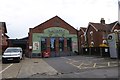
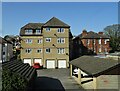
Wine warehouse, Bournemouth Road
This commercial building does not appear on the 1924 OS map, but is there on the 1933 map. It is marked as a stamping works
Image: © David Smith
Taken: 30 Mar 2017
0.16 miles
9
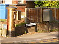
Branksome: postbox № BH14 244, North Lodge Road
This postbox is emptied finally at 5:30pm on weekdays and at noon on Saturdays. The photo may look strangely exposed, but the gold colour is in fact the result of an act of graffiti.
Image: © Chris Downer
Taken: 20 May 2009
0.16 miles
10
Lodge Close, Branksome, Poole
Lodge Close is a residential cul-de-sac in Branksome, a suburb of Poole.
Image: © Malc McDonald
Taken: 25 Aug 2021
0.16 miles