IMAGES TAKEN NEAR TO
Palmerston Road, POOLE, BH14 9HH
Introduction
This page details the photographs taken nearby to Palmerston Road, BH14 9HH by members of the Geograph project.
The Geograph project started in 2005 with the aim of publishing, organising and preserving representative images for every square kilometre of Great Britain, Ireland and the Isle of Man.

There are currently over 7.5m images from over14,400 individuals and you can help contribute to the project by visiting https://www.geograph.org.uk
Image Map
Images are licensed for reuse under creativecommons.org/licenses/by-sa/2.0
Notes
- Clicking on the map will re-center to the selected point.
- The higher the marker number, the further away the image location is from the centre of the postcode.
Image Listing (35 Images Found)
Images are licensed for reuse under creativecommons.org/licenses/by-sa/2.0
Image
Details
Distance
1
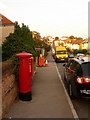
Parkstone: postbox № BH14 169, Palmerston Road
This George V-reign postbox faces down Hardy Road and is emptied finally at 5:30pm on weekdays and at noon on Saturdays.
Image: © Chris Downer
Taken: 9 Aug 2009
0.03 miles
2
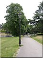
Branksome, lamp post
One of a series of well-maintained lamp posts in Alexandra Park; cast iron, with a barley twist on the stem, and patterns of flowers, dolphins & scallops on the base. Detail picked out silver on black.
Image: © Mike Faherty
Taken: 6 Jun 2009
0.06 miles
3
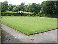
Branksome, bowling green
In Alexandra Park; home of Branksome Park Bowling Club, founded 1926. http://www.branksomeparkbowls.co.uk/
Image: © Mike Faherty
Taken: 6 Jun 2009
0.09 miles
4
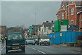
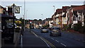
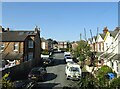
Poole : Bournemouth Road A35
Looking along Bournemouth Road.
Image: © Lewis Clarke
Taken: 27 Mar 2018
0.11 miles
5
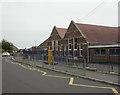
Branksome, Courthill First School
On Courthill & Queen's Roads; dating from 1912, according to a stone plaque. http://www.courthill.poole.sch.uk/site/index.html
Image: © Mike Faherty
Taken: 6 Jun 2009
0.11 miles
6
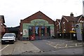
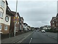
Wine warehouse, Bournemouth Road
This commercial building does not appear on the 1924 OS map, but is there on the 1933 map. It is marked as a stamping works
Image: © David Smith
Taken: 30 Mar 2017
0.11 miles
8
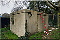
WW2 Air Raid Shelters of Poole - Alexandra Park
-
Civil Air Raid Shelter EDoB ID e48060
In use as an ARP Wardens Post.
Image
Image: © Mike Searle
Taken: 1 Apr 2021
0.11 miles