IMAGES TAKEN NEAR TO
Penn Hill Avenue, POOLE, BH14 9DD
Introduction
This page details the photographs taken nearby to Penn Hill Avenue, BH14 9DD by members of the Geograph project.
The Geograph project started in 2005 with the aim of publishing, organising and preserving representative images for every square kilometre of Great Britain, Ireland and the Isle of Man.

There are currently over 7.5m images from over14,400 individuals and you can help contribute to the project by visiting https://www.geograph.org.uk
Image Map
Images are licensed for reuse under creativecommons.org/licenses/by-sa/2.0
Notes
- Clicking on the map will re-center to the selected point.
- The higher the marker number, the further away the image location is from the centre of the postcode.
Image Listing (40 Images Found)
Images are licensed for reuse under creativecommons.org/licenses/by-sa/2.0
Image
Details
Distance
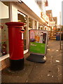
1
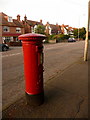
Parkstone: postbox № BH14 52, Penn Hill Avenue
An Edward VII-reign postbox, emptied finally at 5:30pm on weekdays and at noon on Saturdays.
Image: © Chris Downer
Taken: 9 Aug 2009
0.07 miles
2
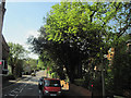
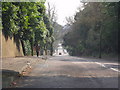
St Osmunds Road Parkstone
At the junction of Bournemouth Road
Image: © John Firth
Taken: 12 May 2010
0.09 miles
3
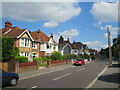
Birchwood Road, Penn Hill, Poole
Birchwood Road is a residential road in Penn Hill, a suburb of Poole.
Image: © Malc McDonald
Taken: 25 Aug 2021
0.09 miles
4
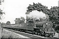
Down empty stock between Branksome and Parkstone
View eastward, towards Bournemouth, Southampton etc.: ex-LSW London - Southampton - Weymouth main line. The train is headed by ex-LSW Urie 'King Arthur' class N15 4-6-0 No. 30740 'Merlin' (built 3/19, withdrawn 12/55).
Image: © Ben Brooksbank
Taken: 16 Jun 1951
0.10 miles
5
Parkstone: postbox № BH14 130, St. Osmund?s Road
This Elizabeth II-reign postbox faces along Overbury Road, and is emptied finally at 5:30pm on weekdays and at noon on Saturdays. It has a drop box (see below) attached to it and another free-standing one alongside.
Image: © Chris Downer
Taken: 9 Aug 2009
0.11 miles
6
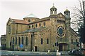
Parkstone: Romanian Orthodox church of St. Dunstan of Canterbury
This extraordinary building in Parkstone was built in 1913 as the parish church of St. Osmund, Parkstone. It remained so until the late 1990s when its closure was forced by structural unsoundness. It was even thought that the roof might collapse imminently. However, it has survived its battle and on 14 April 2005 it changed hands and became the Romanian Orthodox Church's first acquisition in the UK.
See more here: http://archive.bournemouthecho.co.uk/2001/5/16/101158.html , here: http://archive.bournemouthecho.co.uk/2004/5/22/66840.html , and here: http://archive.bournemouthecho.co.uk/2005/6/10/55067.html
Image: © Chris Downer
Taken: Unknown
0.13 miles
7
Parkstone: postbox № BH14 38, Bournemouth Road
This large, modern postbox stands outside the Sainsbury's Local at 104-106 Bournemouth Road, which has opened fairly recently in premises which I seem to recall was a bed or furniture store previously – the Tesco Express diagonally now has some direct competition.
There was actually a post office nearby here – at 81 Bournemouth Road from 1908 to 1963 and then at number 131 until its closure on 31 May 1985. I'm sure this box would have moved with the office before ending up (or being replaced) here.
The postbox is emptied finally at 5:30pm on weekdays and at noon on Saturdays.
Image: © Chris Downer
Taken: 9 Aug 2009
0.13 miles
8
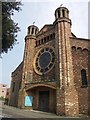
The West Entrance to St Dunstan's Church
This church was originally "St Osmund's" but it has now been taken over by the Christian Orthodox Church, and renamed "St Dunstan's". See their web site at http://www.orthodoxpoole.org.uk/joomla/ for details.
Image: © mike smith
Taken: 1 Apr 2007
0.14 miles
10
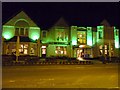
Poole : The Grasshopper
The grasshopper pub with shades of green lighting on Bournemouth Road.
Image: © Lewis Clarke
Taken: 8 Mar 2010
0.14 miles