IMAGES TAKEN NEAR TO
Vale Road, POOLE, BH14 9AT
Introduction
This page details the photographs taken nearby to Vale Road, BH14 9AT by members of the Geograph project.
The Geograph project started in 2005 with the aim of publishing, organising and preserving representative images for every square kilometre of Great Britain, Ireland and the Isle of Man.

There are currently over 7.5m images from over14,400 individuals and you can help contribute to the project by visiting https://www.geograph.org.uk
Image Map
Images are licensed for reuse under creativecommons.org/licenses/by-sa/2.0
Notes
- Clicking on the map will re-center to the selected point.
- The higher the marker number, the further away the image location is from the centre of the postcode.
Image Listing (40 Images Found)
Images are licensed for reuse under creativecommons.org/licenses/by-sa/2.0
Image
Details
Distance
1
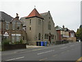
Branksome Masonic Hall
On Ashley Road; apparently originally a chapel, possibly Roman Catholic; leased by Freemasons in 1926. Now houses a collection of Masonic and other artistic artefacts. There is no indication from the outside as to its use, or public access. http://www.freemasonrytoday.com/23/p15.php?printnice=yes
Image: © Mike Faherty
Taken: 6 Jun 2009
0.09 miles
2
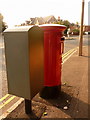
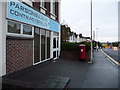
Parkstone: postbox № BH14 47, Alexandra Road
This large Elizabeth II-reign postbox stands by the roundabout where Alexandra Road (left and behind) meets Vale Road (right) and Loch Road (ahead). It is emptied finally at 5:30pm on weekdays and at noon on Saturdays.
Alongside is a grey 'drop box' (see below).
Image: © Chris Downer
Taken: 9 Aug 2009
0.10 miles
3
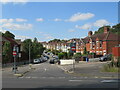
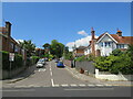
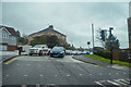
Vale Road, Branksome, Poole
Vale Road is a residential road in Branksome, a suburb of Poole.
"No entry" signs restrict access to the road, prohibiting vehicles from making a right turn to enter the road.
Image: © Malc McDonald
Taken: 25 Aug 2021
0.10 miles
4
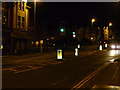
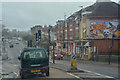
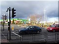
Poole : Bournemouth Road & Traffic Lights
Traffic lights in the road near the junction with Vale and Archway Road.
Image: © Lewis Clarke
Taken: 8 Mar 2010
0.10 miles
5
Crescent Road, Branksome, Poole
Crescent Road is a residential road in Branksome, a suburb of Poole.
Image: © Malc McDonald
Taken: 25 Aug 2021
0.11 miles
6
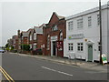
Parkstone: postbox № BH14 26, Ashley Road
The reason for a large postbox being positioned here is that the shop on the left was Ashley Road East Post Office until its closure on 9 February 2004. The remaining Ashley Road West branch now seems rather strangely named since it's now the only one in Ashley Road.
The box is emptied finally at 5:30pm on weekdays and at noon on Saturdays.
There had previously been a single office in Ahsley Road – probably the other one – called plain 'Ashley Road' from 1 September 1893 until 1911 when the second one opened.
Image: © Chris Downer
Taken: 3 Aug 2009
0.11 miles
7
Poole : Bournemouth Road A35
A road heading through Poole.
Image: © Lewis Clarke
Taken: 27 Mar 2018
0.11 miles
8
Branksome, Salvation Army Citadel
In Davis Road, off Ashley Road; as well as services, it offers groups for over 60s, keep fit, parents & toddlers, and has a band.
Image: © Mike Faherty
Taken: 6 Jun 2009
0.11 miles
9
Branksome Retail Park
One of the retail outlets of Branksome Retail Park and the roundabout at the entrance from Poole Road
Image: © Steve Rigg
Taken: 1 Jan 2006
0.12 miles
10
Poole : Archway Road
A road off of Bournemouth Road.
Image: © Lewis Clarke
Taken: 27 Mar 2018
0.12 miles