IMAGES TAKEN NEAR TO
Durrant Road, POOLE, BH14 8TZ
Introduction
This page details the photographs taken nearby to Durrant Road, BH14 8TZ by members of the Geograph project.
The Geograph project started in 2005 with the aim of publishing, organising and preserving representative images for every square kilometre of Great Britain, Ireland and the Isle of Man.

There are currently over 7.5m images from over14,400 individuals and you can help contribute to the project by visiting https://www.geograph.org.uk
Image Map
Images are licensed for reuse under creativecommons.org/licenses/by-sa/2.0
Notes
- Clicking on the map will re-center to the selected point.
- The higher the marker number, the further away the image location is from the centre of the postcode.
Image Listing (27 Images Found)
Images are licensed for reuse under creativecommons.org/licenses/by-sa/2.0
Image
Details
Distance
1
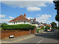
Warwick Road, Parkstone, Poole
Warwick Road is a residential road in Parkstone, a suburb of Poole.
Image: © Malc McDonald
Taken: 25 Aug 2021
0.05 miles
2
Overbury Road, Parkstone, Poole
Overbury Road is a residential road in Parkstone, a suburb of Poole.
Image: © Malc McDonald
Taken: 25 Aug 2021
0.09 miles
3
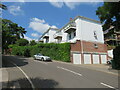
Highbridge Road, Parkstone, Poole
Apartment blocks on Highbridge Road in Parkstone, a suburb of Poole.
Image: © Malc McDonald
Taken: 25 Aug 2021
0.09 miles
4
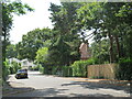
Durrant Road, Parkstone, Poole
Durrant Road is a residential road in Parkstone, a suburb of Poole.
Image: © Malc McDonald
Taken: 25 Aug 2021
0.11 miles
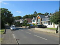
5

St Luke's Church
2007 is the church's centenary year.
Image: © mike smith
Taken: 1 Apr 2007
0.11 miles
6
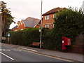
Parkstone: postbox № BH14 31, Kingsbridge Road
A George V-reign postbox, emptied finally at 5:30pm on weekdays and at noon on Saturdays.
Image: © Chris Downer
Taken: 5 Aug 2009
0.12 miles
7
Alton Road, Parkstone, Poole
Alton Road is a residential road in Parkstone, a suburb of Poole.
Image: © Malc McDonald
Taken: 25 Aug 2021
0.12 miles
8

St Lukes Church at Parkestone
Viewed from the north-west.
Image: © Peter Wood
Taken: 27 Mar 2014
0.12 miles
9

Ordnance Survey Cut Mark
This can be found on the wall of St Lukes Church.
For more detail see : http://www.bench-marks.org.uk/bm56256
Image: © Peter Wood
Taken: 27 Mar 2014
0.12 miles
10
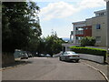
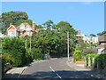
Highmoor Road, Parkstone, Poole
Highmoor Road is a residential road in Parkstone, a suburb of Poole. The apartments to the right of the image have views across Poole Harbour to the Isle of Purbeck.
Image: © Malc McDonald
Taken: 25 Aug 2021
0.12 miles