IMAGES TAKEN NEAR TO
Conifer Avenue, POOLE, BH14 8RU
Introduction
This page details the photographs taken nearby to Conifer Avenue, BH14 8RU by members of the Geograph project.
The Geograph project started in 2005 with the aim of publishing, organising and preserving representative images for every square kilometre of Great Britain, Ireland and the Isle of Man.

There are currently over 7.5m images from over14,400 individuals and you can help contribute to the project by visiting https://www.geograph.org.uk
Image Map
Images are licensed for reuse under creativecommons.org/licenses/by-sa/2.0
Notes
- Clicking on the map will re-center to the selected point.
- The higher the marker number, the further away the image location is from the centre of the postcode.
Image Listing (23 Images Found)
Images are licensed for reuse under creativecommons.org/licenses/by-sa/2.0
Image
Details
Distance
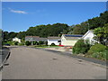
1
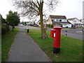
Parkstone: postbox № BH14 51, Conifer Avenue
A George V-reign postbox in a road which had received an unusual form of traffic calming – every other junction has been realigned so that priority is given to turning vehicles while through traffic has to give way several times. One such junction is the one here, with Conifer Avenue ahead and behind and South Western Crescent off to the right.
Image: © Chris Downer
Taken: 10 Jan 2009
0.02 miles
2
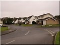
Southwestern Crescent, Poole
Southwestern Crescent is a residential road in Poole.
Image: © Malc McDonald
Taken: 6 Feb 2022
0.03 miles
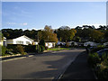
3
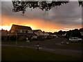
Poole: South Western Crescent
Looking up South Western Crescent from Conifer Avenue. In recent years, a traffic calming scheme has been installed along Conifer Avenue, whereby at each junction the traffic priority swings into the side-road, meaning that through traffic has to continually give way.
The rather desirable properties are seen against a fiery sky, after a very sunny evening followed drizzle for most of the day.
Image: © Chris Downer
Taken: 5 Aug 2009
0.06 miles
4
Jennings Road, Poole
Jennings Road is a residential road in Poole.
Image: © Malc McDonald
Taken: 6 Feb 2022
0.06 miles
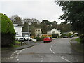
5

Conifer Avenue, Parkstone, Poole
Conifer Avenue is a residential road in Parkstone, a suburb of Poole.
Image: © Malc McDonald
Taken: 25 Aug 2021
0.07 miles
6
Jennings Road, Parkstone, Poole
Jennings Road is a residential road in Parkstone, a suburb of Poole.
Image: © Malc McDonald
Taken: 25 Aug 2021
0.08 miles
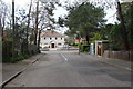
7
Jennings Road, Poole
Looking south along the quiet Jennings Road towards its junction with Broadwater Avenue. This is quite a large estate of chalet style bungalows and houses, probably built in the 1970s.
Image: © Peter Jordan
Taken: 19 Nov 2005
0.09 miles
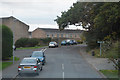
8
Durlston Road at junction with Alton Road
Image: © Ruth Sharville
Taken: 16 Apr 2009
0.15 miles
9
Poole : Pottery Road
Looking along Pottery Road in Poole.
Image: © Lewis Clarke
Taken: 28 Oct 2017
0.15 miles
10
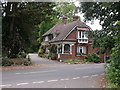
Parkstone Cemetery, lodge
Lodge at the eastern entrance on Pottery Road. http://www.poole.gov.uk/facilities/ref:F465e9bc76ca1f/aka:Parkstone+Cemetery/
Image: © Mike Faherty
Taken: 18 Sep 2009
0.15 miles