IMAGES TAKEN NEAR TO
Anthonys Avenue, POOLE, BH14 8JJ
Introduction
This page details the photographs taken nearby to Anthonys Avenue, BH14 8JJ by members of the Geograph project.
The Geograph project started in 2005 with the aim of publishing, organising and preserving representative images for every square kilometre of Great Britain, Ireland and the Isle of Man.

There are currently over 7.5m images from over14,400 individuals and you can help contribute to the project by visiting https://www.geograph.org.uk
Image Map
Images are licensed for reuse under creativecommons.org/licenses/by-sa/2.0
Notes
- Clicking on the map will re-center to the selected point.
- The higher the marker number, the further away the image location is from the centre of the postcode.
Image Listing (5 Images Found)
Images are licensed for reuse under creativecommons.org/licenses/by-sa/2.0
Image
Details
Distance
1
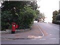
Lilliput: postbox № BH14 141, Compton Avenue
This large Elizabeth II-reign postbox is on the corner of Compton and Anthonys Avenues.
Image: © Chris Downer
Taken: 22 Sep 2008
0.06 miles
2
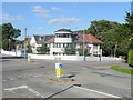
Lilliput Road cross roads
The point where Compton Avenue and Bingham Avenue meet.
In a part of town with extravigant architecture.
Image: © Jonathan Billinger
Taken: 8 Apr 2010
0.19 miles
3
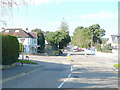
Spot the fox!
A feral animal just rounding the corner of Bingham Avenue and Lilliput Road.
Image: © Jonathan Billinger
Taken: 8 Apr 2010
0.20 miles
4
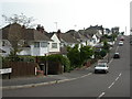
Parkstone, Blake Hill Avenue
A variety of housing, from the 1920s when the estate was originally built, to more modern.
Image: © Mike Faherty
Taken: 19 Sep 2009
0.24 miles
5
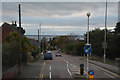
Poole : Lilliput Road
Looking along Lilliput Road in Poole.
Image: © Lewis Clarke
Taken: 28 Oct 2017
0.24 miles