IMAGES TAKEN NEAR TO
Leslie Road, POOLE, BH14 8DN
Introduction
This page details the photographs taken nearby to Leslie Road, BH14 8DN by members of the Geograph project.
The Geograph project started in 2005 with the aim of publishing, organising and preserving representative images for every square kilometre of Great Britain, Ireland and the Isle of Man.

There are currently over 7.5m images from over14,400 individuals and you can help contribute to the project by visiting https://www.geograph.org.uk
Image Map
Images are licensed for reuse under creativecommons.org/licenses/by-sa/2.0
Notes
- Clicking on the map will re-center to the selected point.
- The higher the marker number, the further away the image location is from the centre of the postcode.
Image Listing (44 Images Found)
Images are licensed for reuse under creativecommons.org/licenses/by-sa/2.0
Image
Details
Distance
1
Rising Groundwater?
As I was walking up the hill, on Sandbanks Road, I was met by water at about 20 yards from this location. Thus the 'leak' had only just sprung. After such a wet winter, I can only speculate that this had been caused by high groundwater levels.
Image: © Peter Trimming
Taken: 22 Feb 2014
0.07 miles
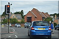
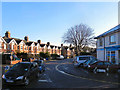
2
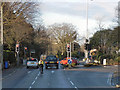
Poole : Parkstone - Sandbanks Road
Sandbanks Road at the traffic lights and the junction with Pottery Road on the left.
Image: © Lewis Clarke
Taken: 8 Mar 2010
0.07 miles
5
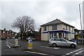
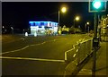
Shop at the end of Pottery Road, Parkstone
Corner shop and post office at the junction with B3369 (Sandbanks Road)
Image: © David Smith
Taken: 13 Feb 2016
0.08 miles
6
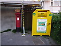
Poole: postbox № BH14 40, Sandbanks Road
This postbox stands outside Westcliff Post Office, which moved from the hardware store opposite into the convenience store, here on the corner of Pottery Road, about 10 years ago. It is emptied finally at 5:30pm on weekdays and at 11:45am on Saturdays, and retains a fairly rare post office direction sign on its top.
Alongside is a clothing recycling bank.
Image: © Chris Downer
Taken: 5 Aug 2009
0.08 miles
7
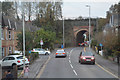
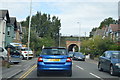
Poole : Sandbanks Road B3369
Ahead is a narrow bridge under the railway.
Image: © Lewis Clarke
Taken: 28 Oct 2017
0.08 miles
9
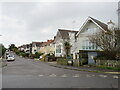
Arley Road, Poole
Arley Road is a residential road in Poole.
Image: © Malc McDonald
Taken: 6 Feb 2022
0.12 miles