IMAGES TAKEN NEAR TO
Glenair Crescent, POOLE, BH14 8AB
Introduction
This page details the photographs taken nearby to Glenair Crescent, BH14 8AB by members of the Geograph project.
The Geograph project started in 2005 with the aim of publishing, organising and preserving representative images for every square kilometre of Great Britain, Ireland and the Isle of Man.

There are currently over 7.5m images from over14,400 individuals and you can help contribute to the project by visiting https://www.geograph.org.uk
Image Map
Images are licensed for reuse under creativecommons.org/licenses/by-sa/2.0
Notes
- Clicking on the map will re-center to the selected point.
- The higher the marker number, the further away the image location is from the centre of the postcode.
Image Listing (65 Images Found)
Images are licensed for reuse under creativecommons.org/licenses/by-sa/2.0
Image
Details
Distance

2
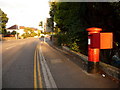
Poole: postbox № BH14 157, Sandbanks Road
This George V-reign postbox is casting an impressively long shadow onto the pavement on this lovely sunny evening, following a drizzly day. It is emptied finally at 5:30pm on weekdays and at 12:45pm on Saturdays.
Image: © Chris Downer
Taken: 5 Aug 2009
0.06 miles
3
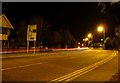
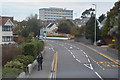
Poole : Sandbanks Road
Sandbanks Road at 7.23pm near the Civic Centre Junction.
Image: © Lewis Clarke
Taken: 8 Mar 2010
0.06 miles
4
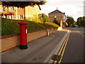
Poole: postbox № BH14 3, Park Road
Park Road forms the western side of a gyratory system which has in its centre a complex including Poole's Civic Centre, courts and Social Security offices. This George VI-reign postbox faces that complex and is emptied finally at 5:30pm on weekdays and at 12:45pm on Saturdays.
Image: © Chris Downer
Taken: 5 Aug 2009
0.06 miles
5

Poole : Park Road & Sandbanks Road
Park Road at the junction with Sandbanks Road in Poole.
Image: © Lewis Clarke
Taken: 3 Jun 2010
0.07 miles
6
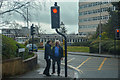
Poole : Park Road A35
Looking along Park Road with two people who appear to know each other at the crossing.
Image: © Lewis Clarke
Taken: 27 Mar 2018
0.07 miles
8
Poole : Sandbanks Road B3369
Looking along Sandbanks Road in Poole.
Image: © Lewis Clarke
Taken: 28 Oct 2017
0.10 miles
9

Glenair Road, Poole
Glenair Road is a residential road in Poole.
This image was taken on a December day. Although the sun was shining brightly, it was low in the sky and shadows were long. The temperature was not much above freezing. Trees had shed most of their leaves for the winter months, with some fallen leaves still on the ground and others still on the trees, yet to fall.
Image: © Malc McDonald
Taken: 10 Dec 2022
0.10 miles
10
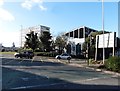
Major intersection on the A35 at Parkstone
Image: © Roger Cornfoot
Taken: 11 Feb 2018
0.11 miles