IMAGES TAKEN NEAR TO
North Road, POOLE, BH14 0LS
Introduction
This page details the photographs taken nearby to North Road, BH14 0LS by members of the Geograph project.
The Geograph project started in 2005 with the aim of publishing, organising and preserving representative images for every square kilometre of Great Britain, Ireland and the Isle of Man.

There are currently over 7.5m images from over14,400 individuals and you can help contribute to the project by visiting https://www.geograph.org.uk
Image Map
Images are licensed for reuse under creativecommons.org/licenses/by-sa/2.0
Notes
- Clicking on the map will re-center to the selected point.
- The higher the marker number, the further away the image location is from the centre of the postcode.
Image Listing (38 Images Found)
Images are licensed for reuse under creativecommons.org/licenses/by-sa/2.0
Image
Details
Distance
1

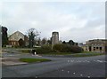
Clock tower and bus shelter, Poole
A clock tower and a bus shelter in Poole. The clock tower was built in 1939, as a memorial to King George V.
Image: © Malc McDonald
Taken: 22 Aug 2021
0.09 miles
2
Parkstone, royal memorial
On a traffic island at the junction of Fernside and Parkstone Roads, overlooking Poole Civic Centre; a clock tower with a plaque "In Memory of our Beloved King George", presumably dating from the year of his death, 1936.
Image: © Mike Faherty
Taken: 31 Dec 2011
0.09 miles
3
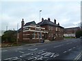
Parkstone, The Sloop
Hall & Woodhouse pub on Commercial Road, overlooking Poole Civic Centre. Internally, oval centre bar, with drinking and eating areas left, front & right on different levels; games machines, TV, patio and apparently old wooden beams. Cask ales on offer at my visit: Badger, Tanglefoot. For some customer comments, see http://www.beerintheevening.com/pubs/s/19/19717/Sloop/Parkstone
Image: © Mike Faherty
Taken: 31 Dec 2011
0.10 miles
4
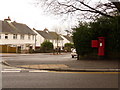
Parkstone: postbox № BH14 132, Danecourt Road
This George VI-reign postbox is emptied finally at 5:30pm on weekdays and at 11:30am on Saturdays. Fernside Avenue is to the left.
Image: © Chris Downer
Taken: 28 Feb 2010
0.10 miles
5
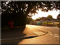
Parkstone: corner of Danecourt Road and Fernside Avenue
The Image (just visible under the tree) must catch direct sunlight only first thing in the morning, thanks to the large tree under which it stands. Now, the sun streams down Danecourt Road towards us.
Image: © Chris Downer
Taken: 9 Aug 2009
0.11 miles
7
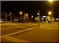
Poole : Commercial Road Junction
Traffic lights on the pedestrian crossing on the junction with Parkstone Road and Commercial Road. Fernside Road also joins here.
Image: © Lewis Clarke
Taken: 8 Mar 2010
0.11 miles
8
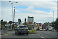
Major intersection on the A35 at Parkstone
Image: © Roger Cornfoot
Taken: 11 Feb 2018
0.12 miles
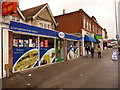
9
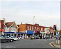
Parade of shops, Parkstone Road, Poole
Image: © nick macneill
Taken: 20 Nov 2011
0.12 miles
10
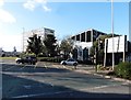
Poole: shops facing Civic Centre
These shops stand on the gyratory system which surrounds the Poole Civic Centre, Police Station and courts. The convenience store in the foreground was also Park Gates Post Office (named because the gates of Poole Park are only a short distance away) until its closure in 2008.
Image: © Chris Downer
Taken: 28 Feb 2010
0.12 miles