IMAGES TAKEN NEAR TO
Gervis Crescent, POOLE, BH14 0LR
Introduction
This page details the photographs taken nearby to Gervis Crescent, BH14 0LR by members of the Geograph project.
The Geograph project started in 2005 with the aim of publishing, organising and preserving representative images for every square kilometre of Great Britain, Ireland and the Isle of Man.

There are currently over 7.5m images from over14,400 individuals and you can help contribute to the project by visiting https://www.geograph.org.uk
Image Map
Images are licensed for reuse under creativecommons.org/licenses/by-sa/2.0
Notes
- Clicking on the map will re-center to the selected point.
- The higher the marker number, the further away the image location is from the centre of the postcode.
Image Listing (64 Images Found)
Images are licensed for reuse under creativecommons.org/licenses/by-sa/2.0
Image
Details
Distance
1
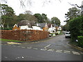
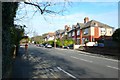
Cherry Close, Parkstone
Cherry Close is a residential cul-de-sac in Parkstone, a suburb of Poole.
Image: © Malc McDonald
Taken: 6 Feb 2022
0.05 miles
2
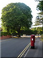
Parkstone: postbox № BH14 172, St. Peter?s Road
This George V-reign postbox is emptied finally at 5:30pm on weekdays and at 11:30am on Saturdays; to the back is attached a drop box (see below). Behind it, we see a rather splendid horse chestnut at the junction of North Road.
Image: © Chris Downer
Taken: 5 Aug 2009
0.08 miles
3
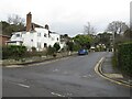
Springfield Crescent, Parkstone
Springfield Crescent is a residential road in Parkstone, a suburb of Poole.
Image: © Malc McDonald
Taken: 6 Feb 2022
0.08 miles
4
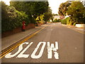
Parkstone: postbox № BH14 55, Springfield Road
A George V-reign postbox, emptied finally at 5:30pm on weekdays and at 11:30am on Saturdays. In the distance we see the turning of Springfield Crescent, which also comes out further down the hill, behind us.
Image: © Chris Downer
Taken: 9 Aug 2009
0.09 miles
5
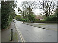
North Rd Poole
View north up this residential road towards Upper Parkstone where it joins the roundabout at the western end of Ashley Rd
Image: © Nigel Mykura
Taken: 14 Feb 2009
0.13 miles
6
Springfield Road, Parkstone
Springfield Road is a residential road in Parkstone, a suburb of Poole.
Image: © Malc McDonald
Taken: 6 Feb 2022
0.14 miles
7
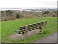
Upper Parkstone viewpoint, near Poole
A viewpoint at Upper Parkstone, with views over Poole Harbour. This image was taken on a dull February day.
Image: © Malc McDonald
Taken: 6 Feb 2022
0.15 miles
8
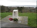
Memorial stone, Constitution Hill viewpoint, Parkstone
A war memorial stone at a viewpoint at Upper Parkstone, overlooking Poole Harbour.
Image: © Malc McDonald
Taken: 6 Feb 2022
0.15 miles
9
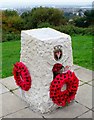
War memorial, Constitution Hill, Bournemouth
Image: © nick macneill
Taken: 17 Nov 2013
0.15 miles
10
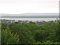
The Viewpoint
A view of Poole harbour looking towards the marina
Image: © Ian Dunckley
Taken: 17 Jun 2005
0.15 miles