IMAGES TAKEN NEAR TO
Rozelle Road, POOLE, BH14 0BX
Introduction
This page details the photographs taken nearby to Rozelle Road, BH14 0BX by members of the Geograph project.
The Geograph project started in 2005 with the aim of publishing, organising and preserving representative images for every square kilometre of Great Britain, Ireland and the Isle of Man.

There are currently over 7.5m images from over14,400 individuals and you can help contribute to the project by visiting https://www.geograph.org.uk
Image Map
Images are licensed for reuse under creativecommons.org/licenses/by-sa/2.0
Notes
- Clicking on the map will re-center to the selected point.
- The higher the marker number, the further away the image location is from the centre of the postcode.
Image Listing (45 Images Found)
Images are licensed for reuse under creativecommons.org/licenses/by-sa/2.0
Image
Details
Distance
1
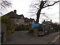
Veterinary centre and bus shelter, Bournemouth Road, Parkstone
Image: © David Smith
Taken: 30 Mar 2017
0.10 miles
2
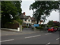
Bournemouth Road Veterinary Centre
Unsurprisingly, on Bournemouth Road, Parkstone. http://www.bournemouthroad.co.uk/
Image: © Mike Faherty
Taken: 6 Jun 2009
0.10 miles
3
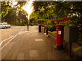
Parkstone: postbox № BH14 14, Bournemouth Road
This Victorian postbox is emptied finally at 5:30pm on weekdays and at noon on Saturdays.
Image: © Chris Downer
Taken: 9 Aug 2009
0.10 miles
4
Poole : Bournemouth Road
A road leading from Bournemouth to Poole. There is a postbox here as well.
Image: © Lewis Clarke
Taken: 8 Mar 2010
0.12 miles
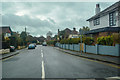
5

Mansfield Road, Parkstone, Poole
Mansfield Road is a residential road in Parkstone, a suburb of Poole.
The road in the foreground is the A35.
Image: © Malc McDonald
Taken: 25 Aug 2021
0.13 miles
6
Poole : Parkside Road
Looking along Parkside Road off of Bournemouth Road.
Image: © Lewis Clarke
Taken: 27 Mar 2018
0.13 miles
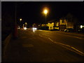
7
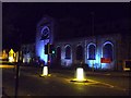
Poole : St Dunstan's Orthodox Church
This church located on Bournemouth Road with a couple of bollards lighting the scene.
Image: © Lewis Clarke
Taken: 8 Mar 2010
0.14 miles
8
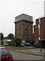
Parkstone Water Tower
Handsomely detailed, Victorian looking water tower near the top of Mansfield Road.
Image: © Mike Faherty
Taken: 6 Jun 2009
0.14 miles
9
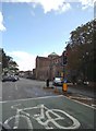
Church Junction
The junction next to St Dunstan's Church on the Bournemouth Road. This church was originally "St Osmund's" but it has now been taken over by the Christian Orthodox Church.
Image: © Gordon Griffiths
Taken: 1 Oct 2016
0.15 miles
10
Parkstone Health Centre
On Mansfield Road, next to Image; as well as doctors' surgeries and pharmacy, the centre offers a wide range of paramedical facilities. http://www.parkstonehealthcentre.co.uk/
Image: © Mike Faherty
Taken: 6 Jun 2009
0.15 miles