IMAGES TAKEN NEAR TO
Tower Road West, POOLE, BH13 6LA
Introduction
This page details the photographs taken nearby to Tower Road West, BH13 6LA by members of the Geograph project.
The Geograph project started in 2005 with the aim of publishing, organising and preserving representative images for every square kilometre of Great Britain, Ireland and the Isle of Man.

There are currently over 7.5m images from over14,400 individuals and you can help contribute to the project by visiting https://www.geograph.org.uk
Image Map
Images are licensed for reuse under creativecommons.org/licenses/by-sa/2.0
Notes
- Clicking on the map will re-center to the selected point.
- The higher the marker number, the further away the image location is from the centre of the postcode.
Image Listing (18 Images Found)
Images are licensed for reuse under creativecommons.org/licenses/by-sa/2.0
Image
Details
Distance
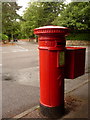
1
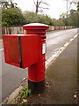
Branksome: postbox № BH13 148, Tower Road West
Having photographed most of the postboxes in the Bournemouth area, with help from the Royal Mail's list of boxes, this one was rather vexing. The list is generally pretty good at describing the location, such as the names of two roads on whose corner a box is situated. This one is described on the list as "Temporary box due to bomb damage" which was most unhelpful.
Anyway I solved the riddle after receiving an email from a chap who is in charge of painting Dorset's postboxes and he told me that it would be found here. The 'temporary' box appears to have found a permanent replacement.
The Edward VII-reign postbox is emptied finally at 5:30pm on weekdays and at 12:15pm on Saturdays.
Image: © Chris Downer
Taken: 28 Feb 2010
0.05 miles
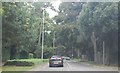
4
The Avenue, Branksome Park, Poole
The B3065, heading north.
Image: © Robin Webster
Taken: 1 Apr 2018
0.17 miles
5

Branksome: postbox № BH13 105, Ormonde Road
This Edward VII-reign postbox is emptied finally at 5:30pm on weekdays and at 11:30am on Saturdays.
Image: © Chris Downer
Taken: 3 Aug 2009
0.18 miles
6
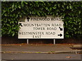
Branksome: sign at Mountbatten/Pinewood/Tower/Westminster Roads junction
A rather baffling sign at first sight, explained by looking at it in its context: Image
Image: © Chris Downer
Taken: 3 Aug 2009
0.20 miles
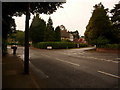
7
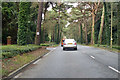
Westminster Road East, near Poole
Westminster Road East, a residential road near Poole.
Image: © Malc McDonald
Taken: 17 Aug 2012
0.20 miles
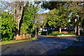
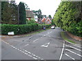
8
Branksome: junction of Mountbatten, Pinewood and Tower Roads with Westminster Road East
This is a peculiar junction in an area of roads with sweeping curves. From left to right, the black car is just turning into Mountbatten Road; if it went straight on it would be in Pinewood Road; to the far right is Westminster Road East (which itself has a junction with Haydon Road just out of picture), while sharp right is a continuation of Tower Road from directly behind us.
See the Image
Image: © Chris Downer
Taken: 3 Aug 2009
0.21 miles
9
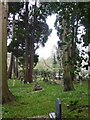
Graves around All Saints church
The church is visible on the right of the picture
Image: © David Smith
Taken: 30 Mar 2017
0.21 miles
10
Branksome: postbox № BH13 83, Tower Road
This Victorian postbox stands at the Image It is emptied finally at 5:30pm on weekdays and at 12:15pm on Saturdays.
Image: © Chris Downer
Taken: 3 Aug 2009
0.21 miles