IMAGES TAKEN NEAR TO
The Avenue, POOLE, BH13 6AE
Introduction
This page details the photographs taken nearby to The Avenue, BH13 6AE by members of the Geograph project.
The Geograph project started in 2005 with the aim of publishing, organising and preserving representative images for every square kilometre of Great Britain, Ireland and the Isle of Man.

There are currently over 7.5m images from over14,400 individuals and you can help contribute to the project by visiting https://www.geograph.org.uk
Image Map
Images are licensed for reuse under creativecommons.org/licenses/by-sa/2.0
Notes
- Clicking on the map will re-center to the selected point.
- The higher the marker number, the further away the image location is from the centre of the postcode.
Image Listing (80 Images Found)
Images are licensed for reuse under creativecommons.org/licenses/by-sa/2.0
Image
Details
Distance
1
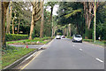
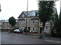
The Avenue, Branksome Park, Poole
The B3065, heading north.
Image: © Robin Webster
Taken: 1 Apr 2018
0.04 miles
2
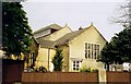
Former St Ambrose, Westbourne
Built in 1880.
Image: © Michael FORD
Taken: Unknown
0.05 miles
3
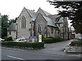
Westbourne: Christ Church
A smallish church just south of central Westbourne. The borough boundary with Poole runs immediately behind the churchyard.
Image: © Chris Downer
Taken: 4 Sep 2008
0.05 miles

5
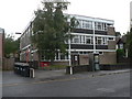
Westbourne: telephone exchange
A typical 1960s telephone exchange building in Alumhurst Road.
Image: © Chris Downer
Taken: 4 Sep 2008
0.10 miles
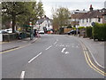
6
Westbourne: flats on old school site
When Bournemouth became a Local Education Authority in 1903, there were two schools in Westbourne: St. Ambrose infants' and the Westbourne British School which became a council school under the Education Act 1902. The latter, particularly, was in overcrowded and entirely inadequate buildings, and in 1907 after discussions with both schools as to future provision in the neighbourhood, nos. 5, 6, 7 and 8 Middle Road were purchased (Middle Road later being renamed R.L. Stevenson Avenue). For a time, nos. 7 and 8 were rented out (13 shillings a week each) while 5 and 6 were demolished in readiness for the school building. The tender of J.M. McWilliams & Son was accepted on 31 December 1907, at a cost of £2,120. The tenants of those two houses were given notice to quit on 25 November 1907 and the buildings were opened on 16 November 1908.
The school closed in July 1962 owing to falling rolls. A special school for those with behavioural difficulties (the 'maladjusted' as they were then called) moved to the site that summer, from premises in Pokesdown, an eastern suburb of Bournemouth. It closed around 1995 when those children were increasingly accommodated in mainstream classes, and was demolished shortly afterwards.
These flats now occupy the site – they are very much in keeping with their older neighbours, incorporating the two-tone brickwork above the doors and windows.
The remnants of the 'School Keep Clear' zig-zag lines are still evident in the roadway.
Image: © Chris Downer
Taken: 4 Sep 2008
0.13 miles
7
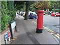
Westbourne: postbox № BH4 118, R. L. Stevenson Avenue
An Edward VII-reign postbox at the southern end of R. L. Stevenson Avenue. Immediately behind the camera is Image, which explains the Stevenson connection.
Image: © Chris Downer
Taken: 4 Sep 2008
0.14 miles
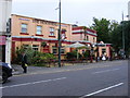
10
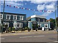
Bournemouth: The Libertine, Westbourne
Image: © Jonathan Hutchins
Taken: 7 Aug 2015
0.15 miles