IMAGES TAKEN NEAR TO
SHIPLEY, BD98 8WZ
Introduction
This page details the photographs taken nearby to BD98 8WZ by members of the Geograph project.
The Geograph project started in 2005 with the aim of publishing, organising and preserving representative images for every square kilometre of Great Britain, Ireland and the Isle of Man.

There are currently over 7.5m images from over14,400 individuals and you can help contribute to the project by visiting https://www.geograph.org.uk
Image Map
Images are licensed for reuse under creativecommons.org/licenses/by-sa/2.0
Notes
- Clicking on the map will re-center to the selected point.
- The higher the marker number, the further away the image location is from the centre of the postcode.
Image Listing (1218 Images Found)
Images are licensed for reuse under creativecommons.org/licenses/by-sa/2.0
Image
Details
Distance
1
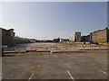
Site of the former Bradford Sorting Office
Royal Mail vacated the site a few years earlier, see Image It has been cleared within the last 3 years.
Image: © Stephen Craven
Taken: 27 May 2018
0.00 miles
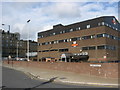
2
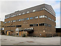
Former Royal Mail building, Canal Road, Bradford
This building now appears to be disused. See Image for a view when it was still in use in 2010.
Image: © Stephen Craven
Taken: 21 Mar 2015
0.01 miles
4
Site of the former Royal Mail Sorting Office, Forster Square
Viewed from the steps leading up to the Cathedral from Bolton Road.
Image: © Stephen Armstrong
Taken: 23 Sep 2018
0.01 miles
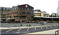
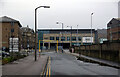
5
Bradford Mail Centre, Forster Court
Image: © Stephen Armstrong
Taken: 18 Sep 2010
0.01 miles
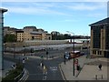
6
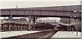
Bradford Forster Square railway station, Yorkshire, 1983
Opened in 1890 as "Bradford Market Street" by the Midland Railway to replace the original 1846 Leeds and Bradford Railway station which had been behind the retaining wall to the left of this image, this station was renamed "Bradford Forster Square" in 1924. It closed in 1990 when it was replaced by a smaller station just to the immediate right and behind the camera position - see Image
View south towards the buffers. See also Image for a 2022 view taken from a little further back and to the left. The retaining wall is the reference point.
Image: © Nigel Thompson
Taken: Unknown
0.01 miles
7
The Broadway seen from Valley Road, Bradford
Image: © habiloid
Taken: 25 Dec 2015
0.03 miles
8
The Broadway seen from Lower Kirkgate, Bradford
Image: © habiloid
Taken: 25 Dec 2015
0.03 miles
9
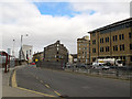
Southern end of Canal Road, Bradford
Viewed from the junction with Lower Kirkgate. There is a bus stop and layby.
Image: © Stephen Craven
Taken: 21 Mar 2015
0.03 miles
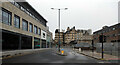
10
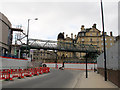
Broadway development, Bradford: temporary bridge
This bridge had been put up to allow construction workers access from the site compound on the other side of Lower Kirkgate without having to negotiate the traffic.
Image: © Stephen Craven
Taken: 21 Mar 2015
0.03 miles