IMAGES TAKEN NEAR TO
Plantation Drive, BRADFORD, BD9 6SR
Introduction
This page details the photographs taken nearby to Plantation Drive, BD9 6SR by members of the Geograph project.
The Geograph project started in 2005 with the aim of publishing, organising and preserving representative images for every square kilometre of Great Britain, Ireland and the Isle of Man.

There are currently over 7.5m images from over14,400 individuals and you can help contribute to the project by visiting https://www.geograph.org.uk
Image Map (Loading...)


Getting Data...Please wait
Leaflet Map data © OpenStreetMap
Images are licensed for reuse under creativecommons.org/licenses/by-sa/2.0
Notes
- Clicking on the map will re-center to the selected point.
- The higher the marker number, the further away the image location is from the centre of the postcode.
Image Listing (32 Images Found)
Images are licensed for reuse under creativecommons.org/licenses/by-sa/2.0
Image
Details
Distance
1
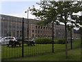
Hallmark's greetings cards factory
Also known locally as Sharp's Printers
Image: © Howard Cleveland
Taken: 28 Jul 2008
0.10 miles
2
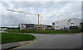
Beckfoot Upper Heaton School, Bradford
Construction of the new school building continues.
Image: © habiloid
Taken: 21 Jun 2016
0.11 miles
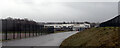
3
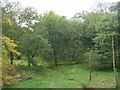
Stoney Ridge Plantation - Bingley Road
Image: © Betty Longbottom
Taken: 2 Oct 2010
0.14 miles
4
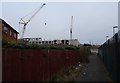
Beckfoot Upper Heaton School, Bradford
The new building for the school is under construction.
Image: © habiloid
Taken: 29 Feb 2016
0.14 miles
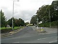
5
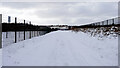
Thorn Lane, Bradford
Access to Chellow Heights School blocked by snow.
Image: © habiloid
Taken: 25 Mar 2013
0.15 miles
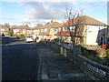
7
Brantwood Drive - viewed from Brantwood Oval
Image: © Betty Longbottom
Taken: 12 Jun 2012
0.17 miles