IMAGES TAKEN NEAR TO
Thorn Lane, BRADFORD, BD9 6NB
Introduction
This page details the photographs taken nearby to Thorn Lane, BD9 6NB by members of the Geograph project.
The Geograph project started in 2005 with the aim of publishing, organising and preserving representative images for every square kilometre of Great Britain, Ireland and the Isle of Man.

There are currently over 7.5m images from over14,400 individuals and you can help contribute to the project by visiting https://www.geograph.org.uk
Image Map
Images are licensed for reuse under creativecommons.org/licenses/by-sa/2.0
Notes
- Clicking on the map will re-center to the selected point.
- The higher the marker number, the further away the image location is from the centre of the postcode.
Image Listing (54 Images Found)
Images are licensed for reuse under creativecommons.org/licenses/by-sa/2.0
Image
Details
Distance
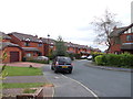
1

Thorn Lane - looking towards Haworth Road
Image: © Betty Longbottom
Taken: 12 Jun 2012
0.02 miles
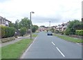

5
Brantwood Drive - viewed from Brantwood Oval
Image: © Betty Longbottom
Taken: 12 Jun 2012
0.09 miles


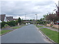
9

Brantdale Road - viewed from Brantwood Oval
Image: © Betty Longbottom
Taken: 12 Jun 2012
0.10 miles
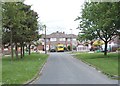
10
Recreation ground, Haworth Road
Construction at Beckfoot Upper Heaton School can be seen in the background.
Image: © habiloid
Taken: 29 Feb 2016
0.11 miles