IMAGES TAKEN NEAR TO
High Park Crescent, BRADFORD, BD9 6HT
Introduction
This page details the photographs taken nearby to High Park Crescent, BD9 6HT by members of the Geograph project.
The Geograph project started in 2005 with the aim of publishing, organising and preserving representative images for every square kilometre of Great Britain, Ireland and the Isle of Man.

There are currently over 7.5m images from over14,400 individuals and you can help contribute to the project by visiting https://www.geograph.org.uk
Image Map
Images are licensed for reuse under creativecommons.org/licenses/by-sa/2.0
Notes
- Clicking on the map will re-center to the selected point.
- The higher the marker number, the further away the image location is from the centre of the postcode.
Image Listing (75 Images Found)
Images are licensed for reuse under creativecommons.org/licenses/by-sa/2.0
Image
Details
Distance
1
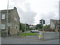
Motorwise Hand Car Wash - Toller Lane
Image: © Betty Longbottom
Taken: 2 Oct 2010
0.04 miles
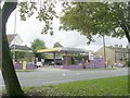
2
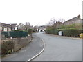
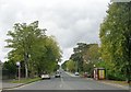
High Park Crescent - High Park Drive
Image: © Betty Longbottom
Taken: 12 Mar 2012
0.06 miles
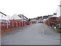
3
Glenview Avenue - looking towards Toller Lane
Image: © Betty Longbottom
Taken: 12 Mar 2012
0.06 miles
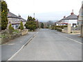
4
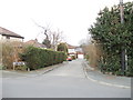
High Park Crescent - High Park Drive
Image: © Betty Longbottom
Taken: 12 Mar 2012
0.07 miles
8
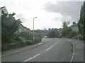
Haworth Road - viewed from Toller Lane
Image: © Betty Longbottom
Taken: 2 Oct 2010
0.09 miles
9
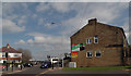
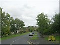
Haworth Road, Bradford
The junction of Haworth Road (B6144) and Bingley Road (B6269). Posters for George Galloway (Respect Party) and the Labour Party for the upcoming general election are on the wall on High Park Drive.
Image: © habiloid
Taken: 22 Apr 2015
0.09 miles