IMAGES TAKEN NEAR TO
Hartman Place, BRADFORD, BD9 5DN
Introduction
This page details the photographs taken nearby to Hartman Place, BD9 5DN by members of the Geograph project.
The Geograph project started in 2005 with the aim of publishing, organising and preserving representative images for every square kilometre of Great Britain, Ireland and the Isle of Man.

There are currently over 7.5m images from over14,400 individuals and you can help contribute to the project by visiting https://www.geograph.org.uk
Image Map
Images are licensed for reuse under creativecommons.org/licenses/by-sa/2.0
Notes
- Clicking on the map will re-center to the selected point.
- The higher the marker number, the further away the image location is from the centre of the postcode.
Image Listing (138 Images Found)
Images are licensed for reuse under creativecommons.org/licenses/by-sa/2.0
Image
Details
Distance
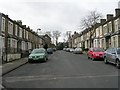
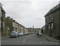
6
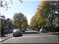
Masham Place viewed from Toller Lane
Image: © Stephen Armstrong
Taken: 14 Feb 2018
0.05 miles
9
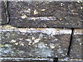
Ordnance Survey Cut Mark
This mark can be found on the roadside garden wall of 180 Toller Lane.
For more details see : http://www.bench-marks.org.uk/bm42650
Image: © Peter Wood
Taken: 19 Apr 2012
0.07 miles