IMAGES TAKEN NEAR TO
Scotchman Road, BRADFORD, BD9 5DD
Introduction
This page details the photographs taken nearby to Scotchman Road, BD9 5DD by members of the Geograph project.
The Geograph project started in 2005 with the aim of publishing, organising and preserving representative images for every square kilometre of Great Britain, Ireland and the Isle of Man.

There are currently over 7.5m images from over14,400 individuals and you can help contribute to the project by visiting https://www.geograph.org.uk
Image Map
Images are licensed for reuse under creativecommons.org/licenses/by-sa/2.0
Notes
- Clicking on the map will re-center to the selected point.
- The higher the marker number, the further away the image location is from the centre of the postcode.
Image Listing (233 Images Found)
Images are licensed for reuse under creativecommons.org/licenses/by-sa/2.0
Image
Details
Distance
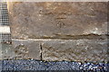
1
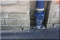
Benchmark on depot on SE side of Scotchman Road
Ordnance Survey cut mark benchmark described on the Bench Mark Database at www.bench-marks.org.uk/bm85019
Image: © Roger Templeman
Taken: 17 Jul 2017
0.03 miles
2

Alan Gee Transport Services depot, Scotchman Road
There is an Ordnance Survey benchmark Image on the wall of the building left of the recessed blue pipe
Image: © Roger Templeman
Taken: 17 Jul 2017
0.03 miles

4
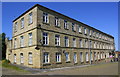
Apartments in former textile mill at Silk Street / Beamsley Road junction
There is an Ordnance Survey benchmark Image on the front of the building about 10m beyond the lamppost near the middle of the block
Image: © Roger Templeman
Taken: 17 Jul 2017
0.07 miles
5
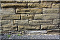
Benchmark on wall of former textile mill on NW side of Beamsley Road
Ordnance Survey cut mark benchmark described on the Bench Mark Database at www.bench-marks.org.uk/bm86594
Image: © Roger Templeman
Taken: 17 Jul 2017
0.07 miles
7

Inverted OS Cut Benchmark, Beamsley Road
This is on the NW side of Beamsley Road just SW of an electricity substation. Details at https://www.bench-marks.org.uk/bm85020
Image: © Stephen Armstrong
Taken: 1 Apr 2018
0.07 miles
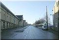
8

Electricity Substation, Beamsley Road
This is in the middle of the Lister's Mills complex, There is an inverted OS Cut Benchmark Image at the bottom of the curved stone, left of the substation.
Image: © Stephen Armstrong
Taken: 1 Apr 2018
0.07 miles
9

Lister textile mill, Heaton Road
There is an Ordnance Survey benchmark Image on the third stone above the pavement in the wall right of the white pipe left of Studio Twelve's office window
Image: © Roger Templeman
Taken: 17 Jul 2017
0.07 miles
10
Benchmark on Lister's Mill, Heaton Road
Ordnance Survey cut mark benchmark described on the Bench Mark Database at www.bench-marks.org.uk/bm85018
Image: © Roger Templeman
Taken: 17 Jul 2017
0.07 miles